Show the map
Evaluated Track - ITRA
Ecomaratona dei due Parchi 2018 - EM2P


43.5 km
1390 m
1390 m
 Rifugio Premuda (IT)
 4
4 380
380
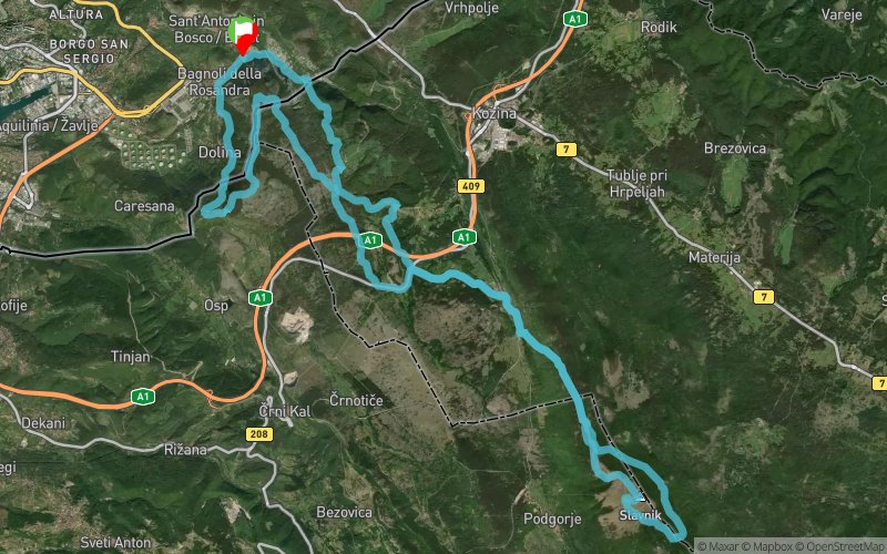
La EM2P è un raduno per amanti del gran fondo in montagna.
I suoi percorsi si sviluppano quasi esclusivamente su strade sterrate e sentieri situati a cavallo tra il territorio di Trieste e la regione slovena Primorska/Litorale.
L'Ecomaratona, si chiama "dei 2 Parchi" perché unisce i due Parchi naturali della Val Rosandra e dello Slavnik.
La quota più bassa di questo percorso, 70m s.l.m., posta nei pressi delle sorgenti dell'Antro di Bagnoli/Jama, si contrappone ai 1028 m della cima del M. Slavnik/Taiano, conferendo alla corsa 1000m di dislivello di salita ed altrettanti di discesa.
Points of Interest table
| Accum. | Intermediary | |||||||
|---|---|---|---|---|---|---|---|---|
| POI | Description | Alt. | Dist. | D+ | D- | Dist. | D+ | D- |
 Competition organized on 10/14/2018
Trace n°66948
Ascent threshold : 3 m Distance threshold : 30 m Smoothing : Yes Origin of altitudes : MNT Google
Ascent threshold : 3 m Distance threshold : 30 m Smoothing : Yes Origin of altitudes : MNT Google
Loop
Dominant terrain : Footpath
Max alti. : 1009 m
Avg alti. : 498 m
Min alti. : 59 m
Longest ascent : 490 m
Longest descent : 650 m
Dominant terrain : Footpath
Max alti. : 1009 m
Avg alti. : 498 m
Min alti. : 59 m
Longest ascent : 490 m
Longest descent : 650 m
Elevation profile
More tools
Create a new roadbook page
Map and track on your website
Warning ! When you insert a Trace de Trail map on your website, you agree not to hide any element of the module (links to Trail Trail or Trail Connect banner)
Add a realisation
Validate
Add a realisation to share your chrono and describe the conditions that you encountered during you trail running !
Add a comment
Validate
Show the infos
Warning ! This track is only accessible on the day of the competition.
Add a track


