Show the map
Trail du petit Som 3 jours de Chartreuse
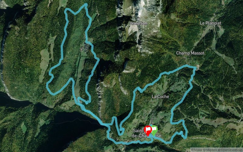


22.8 km
1511 m
1507 m
 Saint-Pierre-de-Chartreuse (38)
 Saint-Pierre-de-Chartreuse (38)
 Points of Interest table
| Accum. | Intermediary | |||||||
|---|---|---|---|---|---|---|---|---|
| POI | Description | Alt. | Dist. | D+ | D- | Dist. | D+ | D- |
 Competition organized on 05/11/2013
Trace n°603
Ascent threshold : 0 m Distance threshold : 35 m Smoothing : Yes Origin of altitudes : MNT Aster GDEM
Ascent threshold : 0 m Distance threshold : 35 m Smoothing : Yes Origin of altitudes : MNT Aster GDEM
Crossing
Dominant terrain : Footpath
Max alti. : 1243 m
Avg alti. : 998 m
Min alti. : 790 m
Longest ascent : 359 m
Longest descent : 595 m
Dominant terrain : Footpath
Max alti. : 1243 m
Avg alti. : 998 m
Min alti. : 790 m
Longest ascent : 359 m
Longest descent : 595 m
Elevation profile
More tools
Create a new roadbook page
Map and track on your website
Warning ! When you insert a Trace de Trail map on your website, you agree not to hide any element of the module (links to Trail Trail or Trail Connect banner)
Add a realisation
Validate
Add a realisation to share your chrono and describe the conditions that you encountered during you trail running !
05/05/13 04:09:08
Praufa
Premier trail de montagne avec ce parcours de replis V2 du trail du petit som de 19km originalement, rallongé à 23/24km pour cause d'enneigement trop important sur certains versant.
Plus grande distance que j'ai faite et dénivelé important 1500m D+ donc je suis parti sans prétention tranquillement dans la seule idée de finir, c'était dur pour un normand comme moi avec mon manque d'entrainement (une seule vraie semaine comme prépa sa pèse pas lourd) mais j'ai gérer ma course en prenant mon temps sur les ravitos et même pour prendre une ou deux photos du monastère, j'ai prit énormément de plaisir a faire ce parcours très joli c'est le principal seul bémol les chemins très gras du au mauvais temps des derniers jours avant la course mais on y peut rien et on fait avec.">
Add a comment
Validate
Admin - Trace de Trail
18/05/13, 21:18:07
Bon, comme quoi, c'est pas évident de savoir...
Bien joué l'avatar David
Je vais bientôt ajouter une fonctionnalité pour qu'il soit possible de s'abonner par mail aux fils de commentaire comme celui-ci, sinon c'est un peu galère...
18/05/13, 21:18:07
Bon, comme quoi, c'est pas évident de savoir...
Bien joué l'avatar David
Je vais bientôt ajouter une fonctionnalité pour qu'il soit possible de s'abonner par mail aux fils de commentaire comme celui-ci, sinon c'est un peu galère...
More comments
Admin - Trace de Trail
13/05/13, 18:07:07
David tu avais combien toi ?
Praufa, ça dépend pas mal des paramètres de réglage de ton GPS, en particulier du nombre total de points. Après il y a plusieurs paramètres qu'il est possible d'ajuster lors de l'import du gpx et de la création de la trace.
Il y a un onglet dans l'aide, ajouté depuis peu, qui explique tout cela !
Et félicitations à tous les deux pour votre perf !
Admin - Trace de Trail
11/05/13, 17:04:32
Ah oui je me doutais que c'était quelqu'un de ta famille en regardant les résultats !
11/05/13, 17:04:32
Ah oui je me doutais que c'était quelqu'un de ta famille en regardant les résultats !
daviddepardon
11/05/13, 17:01:16
Oui ça c'est plutôt bien passé. Je l'ai fait tranquille sans pression. Le parcours était vraiment superbe même s'il était très "gras". Je l'ai fait avec mon frangin, du moins au dans les premier kms puisqu'il m'a mis 11 mn. 45ème pour son 1er trail, c'est une belle perf.
11/05/13, 17:01:16
Oui ça c'est plutôt bien passé. Je l'ai fait tranquille sans pression. Le parcours était vraiment superbe même s'il était très "gras". Je l'ai fait avec mon frangin, du moins au dans les premier kms puisqu'il m'a mis 11 mn. 45ème pour son 1er trail, c'est une belle perf.
Admin - Trace de Trail
11/05/13, 16:35:28
Ça a été David ? pas trop de neige et de boue ?
Je crois qu'ils ont appelé le parcours "trail du monastère" pour finir...
11/05/13, 16:35:28
Ça a été David ? pas trop de neige et de boue ?
Je crois qu'ils ont appelé le parcours "trail du monastère" pour finir...
Show the infos
Add a track


