Show the map
Evaluated Track - ITRA
Méribel Trail 2021 - 25 km
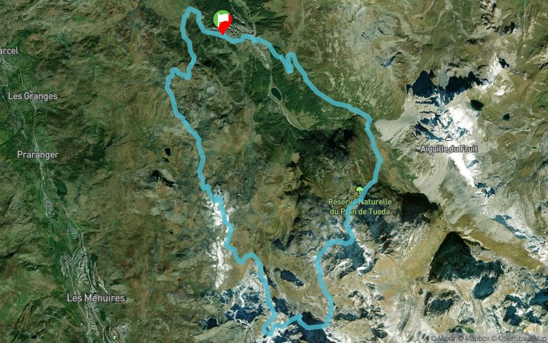


24.4 km
1700 m
1700 m
 Méribel Mottaret (73)
 8
8 Points of Interest table
| Accum. | Intermediary | |||||||
|---|---|---|---|---|---|---|---|---|
| POI | Description | Alt. | Dist. | D+ | D- | Dist. | D+ | D- |
 Competition organized on 08/08/2021
Trace n°137282
Ascent threshold : 3 m Distance threshold : 30 m Smoothing : Yes Origin of altitudes : MNT Google
Ascent threshold : 3 m Distance threshold : 30 m Smoothing : Yes Origin of altitudes : MNT Google
Loop
Dominant terrain : Footpath
Max alti. : 2700 m
Avg alti. : 2297 m
Min alti. : 1685 m
Longest ascent : 980 m
Longest descent : 590 m
Dominant terrain : Footpath
Max alti. : 2700 m
Avg alti. : 2297 m
Min alti. : 1685 m
Longest ascent : 980 m
Longest descent : 590 m
Elevation profile
More tools
Create a new roadbook page
Map and track on your website
Warning ! When you insert a Trace de Trail map on your website, you agree not to hide any element of the module (links to Trail Trail or Trail Connect banner)
Add a realisation
Validate
Add a realisation to share your chrono and describe the conditions that you encountered during you trail running !
Add a comment
Validate
Jean-baptiste73120
14/07/21, 21:47:41
Bonjour Est-ce possible de me transmettre le tracé par mail ? Merci beaucoup d’avance
14/07/21, 21:47:41
Bonjour Est-ce possible de me transmettre le tracé par mail ? Merci beaucoup d’avance
Show the infos
Add a track


