Show the map
OFFICIAL ROUTE
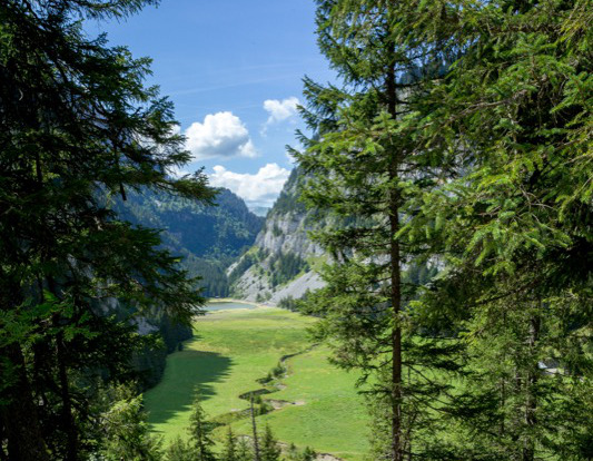
Lac de Flaine (n°7 Flaine)


8.8 km
440 m
440 m
 Flaine (74)
From the Grandes Platières cable car station, descend to La Plaine du Lac de Flaine (viewpoint n°1). Follow the road heading towards Flaine snow front and take the GR96 towards the lake (after the PO car park). Cross the little Hameau des Chalets de la Plaine du Lac around which several herds of cows graze. Leave the path to follow the trail that remains at the foot of the cliffs to get to the Col du Cou. At the crossroads of the Col du Cou, head towards ”Les Gérats-Plaine Joux”. At the next crossroads, follow signs to Les Gérats. The path zig-zags over Le Flan de l’Arbaron on its way to Les Gérats chalets, now a ruin (viewpoint n°2). Cross the Gérats Alpine pasture to reach Le Hameau de Flaine, Flaine Forêt (Chalet Le Bissac), and finally, the Grandes Platières cable car station.
Points of Interest table
| Accum. | Intermediary | |||||||
|---|---|---|---|---|---|---|---|---|
| POI | Description | Alt. | Dist. | D+ | D- | Dist. | D+ | D- |
Trace n°116604
Ascent threshold : 3 m Distance threshold : 30 m Smoothing : Yes Origin of altitudes : MNT IGN
Ascent threshold : 3 m Distance threshold : 30 m Smoothing : Yes Origin of altitudes : MNT IGN
Loop
Dominant terrain : Footpath
Max alti. : 1833 m
Avg alti. : 1619 m
Min alti. : 1416 m
Longest ascent : 410 m
Longest descent : 190 m
Route completed by the author : Yes
Dominant terrain : Footpath
Max alti. : 1833 m
Avg alti. : 1619 m
Min alti. : 1416 m
Longest ascent : 410 m
Longest descent : 190 m
Route completed by the author : Yes
Elevation profile
More tools
Create a new roadbook page
Map and track on your website
Warning ! When you insert a Trace de Trail map on your website, you agree not to hide any element of the module (links to Trail Trail or Trail Connect banner)
Add a realisation
Validate
Add a comment
Validate
Nuits
18/08/23, 17:00:03
Belle randonnée, la montée aux gérats est longues et soutenue . Mais ça se fait !!
18/08/23, 17:00:03
Belle randonnée, la montée aux gérats est longues et soutenue . Mais ça se fait !!
Della
08/08/23, 10:13:09
Randonnée sympa avec de belles vues,rencontre avec 3 bouquetins au niveau de la falaise Gerats .eviter avec enfants non espérimentés sinon les portés dans le sac à dos ????
08/08/23, 10:13:09
Randonnée sympa avec de belles vues,rencontre avec 3 bouquetins au niveau de la falaise Gerats .eviter avec enfants non espérimentés sinon les portés dans le sac à dos ????
More comments
BenardFamily
26/07/23, 21:22:21
Balade sympa, mais le lac n’est pas très grand. malheureusement la météo n’y était pas, nous avons tout remonté sous la pluie. Y aller avec des enfants expérimentés. Montée et descente pas évidente, il faut être vigilants. Il y a de plus belles randonnées à faire avant celle-ci.
26/07/23, 21:22:21
Balade sympa, mais le lac n’est pas très grand. malheureusement la météo n’y était pas, nous avons tout remonté sous la pluie. Y aller avec des enfants expérimentés. Montée et descente pas évidente, il faut être vigilants. Il y a de plus belles randonnées à faire avant celle-ci.
Sabrinalilya
05/07/23, 13:24:01
Balade faite avec deux enfants de 8 et 12 ans assez expérimentés . La descente vers le lac via le torrent très difficile , avec chaînes et cordes . Beaucoup de crevasses . Ce qui rend la descente difficile . A partir du col du cou , la montée est très soutenue sur au moins une heure . Prévoir un troisième poumon !! De peaux paysages en perspective .
Momo77
21/08/22, 09:19:19
Belle balade. Mais attention avec des enfants… La descente au lac est raide (passage avec chaîne pour aide à la descente) et la partie du col aux Gerats est difficile ! À faire plutôt avec des ados ou des enfants expérimentés en rando
21/08/22, 09:19:19
Belle balade. Mais attention avec des enfants… La descente au lac est raide (passage avec chaîne pour aide à la descente) et la partie du col aux Gerats est difficile ! À faire plutôt avec des ados ou des enfants expérimentés en rando
Show the infos
Add a track

