Show the map
Olhette - Ziburumendi - La Rhune
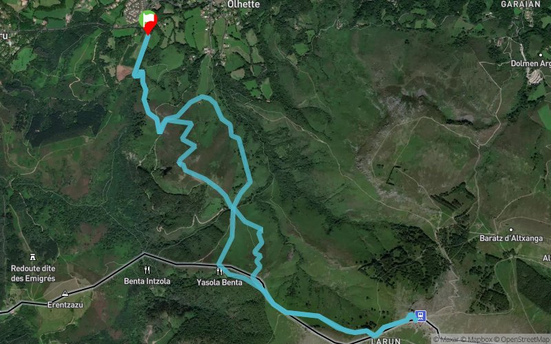


12.6 km
1020 m
1020 m
 Ascain (64)
 Points of Interest table
| Accum. | Intermediary | |||||||
|---|---|---|---|---|---|---|---|---|
| POI | Description | Alt. | Dist. | D+ | D- | Dist. | D+ | D- |
Trace n°81911
Ascent threshold : 3 m Distance threshold : 30 m Smoothing : No Origin of altitudes : MNT Aster GDEM
Ascent threshold : 3 m Distance threshold : 30 m Smoothing : No Origin of altitudes : MNT Aster GDEM
Loop
Dominant terrain : Footpath
Max alti. : 848 m
Avg alti. : 387 m
Min alti. : 49 m
Longest ascent : 580 m
Longest descent : 870 m
Route completed by the author : Yes
Dominant terrain : Footpath
Max alti. : 848 m
Avg alti. : 387 m
Min alti. : 49 m
Longest ascent : 580 m
Longest descent : 870 m
Route completed by the author : Yes
Elevation profile
More tools
Create a new roadbook page
Map and track on your website
Warning ! When you insert a Trace de Trail map on your website, you agree not to hide any element of the module (links to Trail Trail or Trail Connect banner)
Add a realisation
Validate
Add a realisation to share your chrono and describe the conditions that you encountered during you trail running !
Add a comment
Validate
mlaure242006
07/07/20, 17:00:44
surtout ne pas emprunter cette trace elle n'est absolument plus praticable sauf si vous aimez les ronces et galérer impossible de courir
07/07/20, 17:00:44
surtout ne pas emprunter cette trace elle n'est absolument plus praticable sauf si vous aimez les ronces et galérer impossible de courir
Show the infos
Add a track


