
La Ferme Trail 2018
ITRA
 23.3 km
1050 m
1050 m
23.3 km
1050 m
1050 m

J'aime
Favoris
Avis
Partager
GPX
8
PDF A4
PDF A0
Profil
Flyover
3D
Insérer
Passages
Inconnu (MU) Inconnu (MU)
Kilomètre effort
Plus longue montée
Plus longue descente
33
510 m
560 m
Altitude max
Altitude min
Indice de qualité
669 m
112 m
 1pt/3m
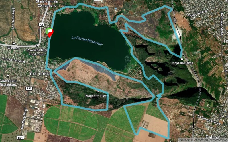
The trail begins at the La Ferme Reservoir wall and proceeds along the dam bank and vegetable gardens for 3km before climbing slowly at frst then more rapidly, up the Corps de Garde mountain, giving wonderful views of all Mauritius, until arriving at the summit. Then, the path plunges rapidly down over hyper-technical paths, not for the faint-hearted!, back down to the La Ferme lake, going along the emuddy edge and then climbing the pass between the Corps de Garde mountain and the Montagne St-Pierre through forest, then passing 4km oaver flat canefields, time to recover, then down the pass again, round the base of the St-Pierre mountain, then up to its summit at 550m, down through technical paths and round the base, through the Bambous village and back to the starting point.
En voir plus... En voir moins...

Départ
Distance
0 km
Altitude
129 m
D+
0 m
D-
0 m
23.3 km
1050 m
1050 m
Arrivée
Distance
23.3 km
Altitude
129 m
D+
1050 m
D-
1050 m
Cliquez sur un point d'intérêt pour l'afficher sur la carte
Avis et chronos
Ajouter une trace
La Ferme Trail 2018

Numéro de trace : 50799
Lien vers la trace :
https://tracedetrail.fr/fr/trace/50799
Connectez-vous pour insérer cette trace sur votre site web
 Trace de Trail