
La Ferme Trail 2018
ITRA
 23.3 km
1050 m
1050 m
23.3 km
1050 m
1050 m

Like
Favorites
Reviews
Share
GPX
8
PDF A4
PDF A0
Profile
Flyover
3D
Insert
Passages
Inconnu (MU) Inconnu (MU)
Effort kilometer
Longest ascent
Longest descent
33
510 m
560 m
Max. elevation
Min. elevation
Quality index
669 m
112 m
 1pt/3m
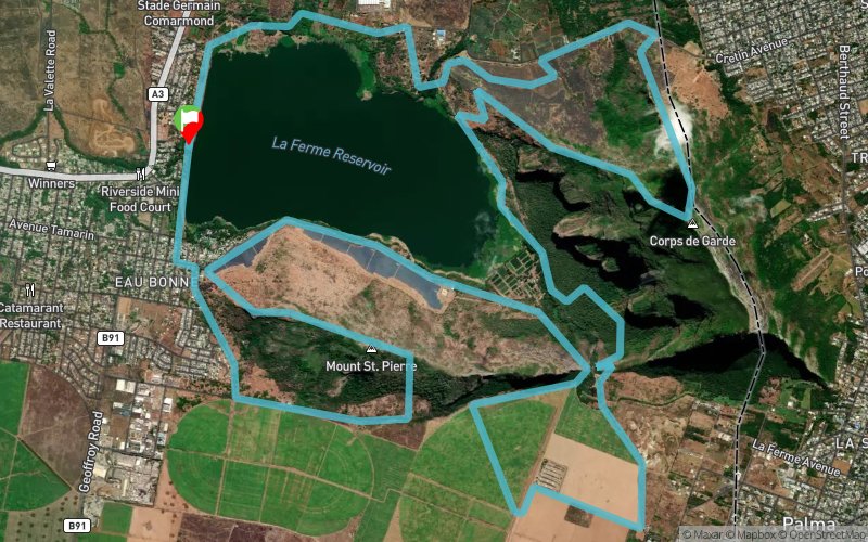
The trail begins at the La Ferme Reservoir wall and proceeds along the dam bank and vegetable gardens for 3km before climbing slowly at frst then more rapidly, up the Corps de Garde mountain, giving wonderful views of all Mauritius, until arriving at the summit. Then, the path plunges rapidly down over hyper-technical paths, not for the faint-hearted!, back down to the La Ferme lake, going along the emuddy edge and then climbing the pass between the Corps de Garde mountain and the Montagne St-Pierre through forest, then passing 4km oaver flat canefields, time to recover, then down the pass again, round the base of the St-Pierre mountain, then up to its summit at 550m, down through technical paths and round the base, through the Bambous village and back to the starting point.
En voir plus... En voir moins...

Start
Distance
0 km
Altitude
129 m
D+
0 m
D-
0 m
23.3 km
1050 m
1050 m
Finish
Distance
23.3 km
Altitude
129 m
D+
1050 m
D-
1050 m
Click on a point of interest to display it on the map
Reviews and times
Add a track
La Ferme Trail 2018

Track number : 50799
Link to track :
https://tracedetrail.fr/en/trace/50799
Log in to insert this track on your website
 Trace de Trail