
NPT
ITRA
 57.11 km
2731 m
2731 m
57.11 km
2731 m
2731 m


J'aime
Favoris
Avis
Partager
GPX
8
PDF A4
PDF A0
Profil
Flyover
3D
Insérer
Passages
Weang Hang (TH) Weang Hang (TH)
Kilomètre effort
Plus longue montée
Plus longue descente
84
820 m
830 m
Altitude max
Altitude min
Indice de qualité
1354 m
391 m
 1pt/13m
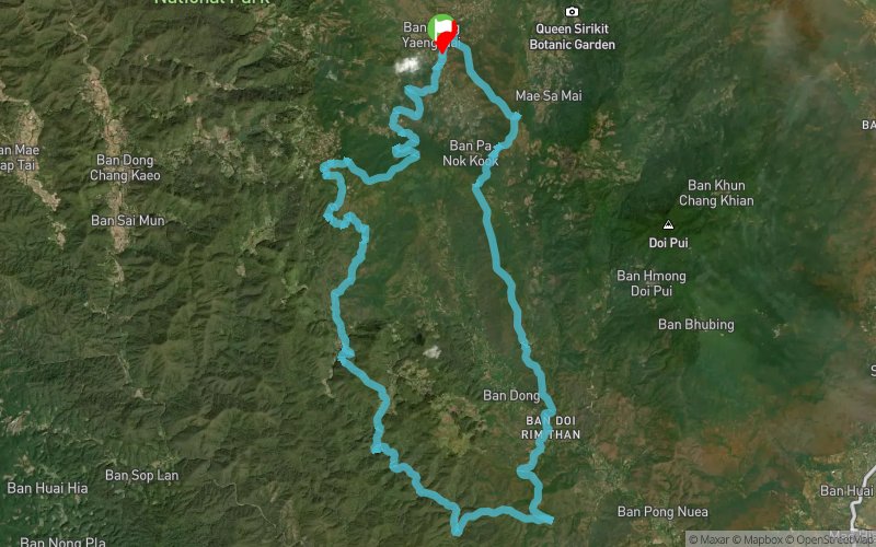
The River Loop, the Nin Prapa Trail (NPT), as the name suggests, will follow the course of streams and rivers to the very bottom and Southernmost of the route before climbing back up slowly to where you started.
Most runners need to pay more attention to the time it takes to complete the loop, so be prepared that it might take you longer than anticipated!
En voir plus... En voir moins...

Départ
Distance
0 km
Altitude
781 m
D+
0 m
D-
0 m
57.1 km
2731 m
2731 m
Arrivée
Distance
57.1 km
Altitude
781 m
D+
2731 m
D-
2731 m
Cliquez sur un point d'intérêt pour l'afficher sur la carte
Avis et chronos
Ajouter une trace
Pong Yaeng Trail NPT

Numéro de trace : 263802
Lien vers la trace :
https://tracedetrail.fr/fr/trace/263802
Connectez-vous pour insérer cette trace sur votre site web
 Trace de Trail