
'In the Raw' Trail Run 2022 - 15 km
ITRA
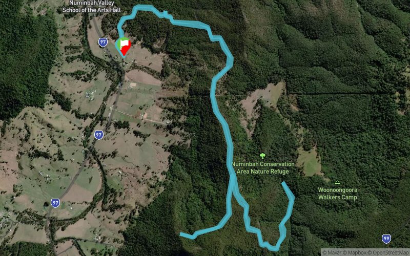
 15.1 km
590 m
590 m
15.1 km
590 m
590 m

J'aime
Favoris
Avis
Partager
GPX
4
PDF A4
PDF A0
Profil
Flyover
3D
Insérer
Passages
Numinbah Valley (AU) Numinbah Valley (AU)
Kilomètre effort
Plus longue montée
Plus longue descente
21
300 m
350 m
Altitude max
Altitude min
Indice de qualité
197 m
-139 m
 1pt/11m
A steady uphill start is softened by the knowledge you get to run all the way back down again to the finish!
Largely shaded, after you make your initial ascent, you'll dive down and enjoy running beside Waterfall Creek. Another up after you turn around at the creek, followed by an undulating out and back section before the long 4.5km descent home!
Trace créée par Trail Trips & Events
le 18/11/2021 (modifiée le 19/11/2021)
le 18/11/2021 (modifiée le 19/11/2021)

Départ
Distance
0 km
Altitude
-128 m
D+
0 m
D-
0 m
15.1 km
590 m
590 m
Arrivée
Distance
15.1 km
Altitude
-128 m
D+
590 m
D-
590 m
Cliquez sur un point d'intérêt pour l'afficher sur la carte
Avis et chronos
Ajouter une trace
'In the Raw' Trail Run 2022 - 15 km

Numéro de trace : 166406
Lien vers la trace :
https://tracedetrail.fr/fr/trace/166406
Connectez-vous pour insérer cette trace sur votre site web
 Trace de Trail