
'In the Raw' Trail Run 2022 - 15 km
ITRA
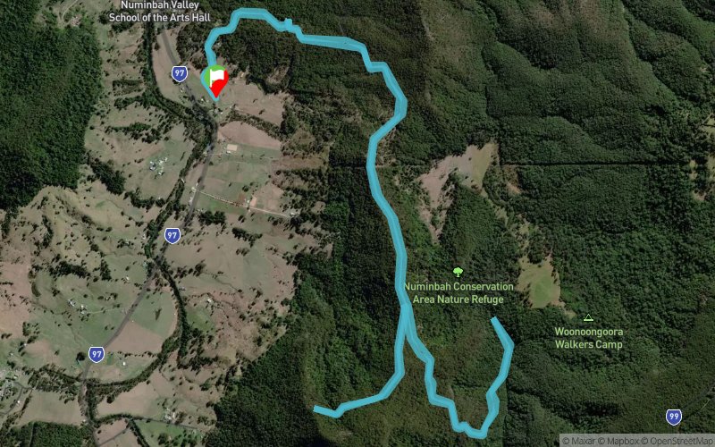
 15.1 km
590 m
590 m
15.1 km
590 m
590 m

Like
Favorites
Reviews
Share
GPX
4
PDF A4
PDF A0
Profile
Flyover
3D
Insert
Passages
Numinbah Valley (AU) Numinbah Valley (AU)
Effort kilometer
Longest ascent
Longest descent
21
300 m
350 m
Max. elevation
Min. elevation
Quality index
197 m
-139 m
 1pt/11m
A steady uphill start is softened by the knowledge you get to run all the way back down again to the finish!
Largely shaded, after you make your initial ascent, you'll dive down and enjoy running beside Waterfall Creek. Another up after you turn around at the creek, followed by an undulating out and back section before the long 4.5km descent home!
Track created by Trail Trips & Events
le 2021/11/18 (modified on 2021/11/19)
le 2021/11/18 (modified on 2021/11/19)

Start
Distance
0 km
Altitude
-128 m
D+
0 m
D-
0 m
15.1 km
590 m
590 m
Finish
Distance
15.1 km
Altitude
-128 m
D+
590 m
D-
590 m
Click on a point of interest to display it on the map
Reviews and times
Add a track
'In the Raw' Trail Run 2022 - 15 km

Track number : 166406
Link to track :
https://tracedetrail.fr/en/trace/166406
Log in to insert this track on your website
 Trace de Trail