Afficher la carte
Plaine Joux - Lac Vert - Châtelet d'Ayères - Chalets du Souay - Lac de Pormenaz - Chalets d'Ayères


 Servoz (74)
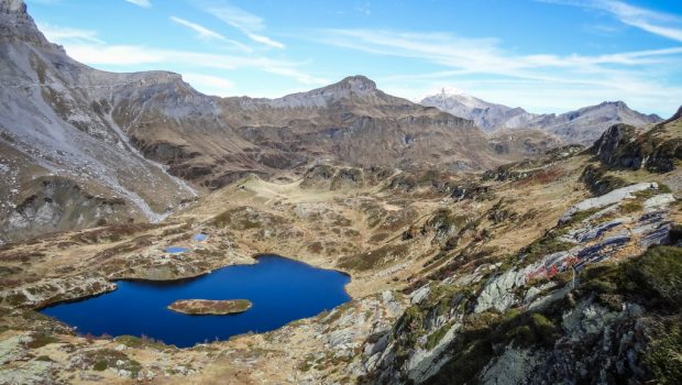
In the heart of Passy National Nature Reserve, the Lac de Pormenaz, overlooked by the imposing eponymous Pointe Noire and Rochers des Fiz, is a must-see summer outing.
The route quickly leads to the Torrent du Souay to finally rise more frankly once arrived at La Chorde where cables and ladders will help pass a few difficulties.
The Aravis Range and the Fiz Massif will appear as a permanent backdrop throughout the ascent. Swimming in the Lac de Pormenaz can be a refreshing break before the descent towards Argentières locality and the Chalets d’Ayères.
For people prone to fear of heights, it is possible to avoid the passages with cables by leaving on the right the trail of La Chorde at the junction.
Table des passages
| Cumul | Intermédiaire | |||||||
|---|---|---|---|---|---|---|---|---|
| Passage | Description | Alt. | Dist. | D+ | D- | Dist. | D+ | D- |
Trace n°64831
Seuil de dénivelé : 5 m Seuil de distance : 30 m Lissage : Oui Origine des altitudes : MNT Aster GDEM
Seuil de dénivelé : 5 m Seuil de distance : 30 m Lissage : Oui Origine des altitudes : MNT Aster GDEM
Boucle
Terrain dominant : Chemin
Alti. max. : 1967 m
Alti. moyenne : 1572 m
Alti. min. : 1300 m
+ longue montée : 700 m
+ longue descente : 410 m
Parcours effectué par l'auteur : Oui
Terrain dominant : Chemin
Alti. max. : 1967 m
Alti. moyenne : 1572 m
Alti. min. : 1300 m
+ longue montée : 700 m
+ longue descente : 410 m
Parcours effectué par l'auteur : Oui
Profils altimétriques
Plus d'outils
Créer une page de roadbook
Carte et profil sur votre site web
Attention ! En insérant une carte Trace de Trail sur votre site web, vous vous engagez à ne masquer aucun élément du module (liens vers Trace de Trail ou bannière Trail Connect), que ce soit en utilisant l'iframe ou le widget.
Ajouter une réalisation
Valider
Ajoutez une réalisation pour partager votre chrono et détailler les conditions que vous avez recontrées lors de votre sortie trail !
Ajouter un commentaire
Valider
Afficher les infos
Ajouter une trace


