
Wicklow Way Race 2017
ITRA
 130.8 km
4140 m
4170 m
130.8 km
4140 m
4170 m


GPX
55
PDF
Profil
Partager
3D
Favoris
Avis
J'aime
Dublin 14 (IE) Inconnu (IE)
Kilomètre effort
Plus longue montée
Plus longue descente
172
460 m
460 m
Altitude max
Altitude min
Indice de qualité
625 m
45 m
 1pt/11m
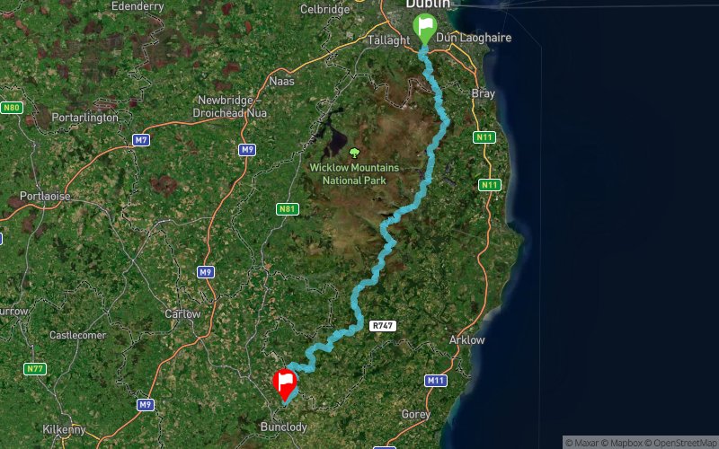
A race over the Wicklow Way from Marlay Park to Clonegal with a maximum allowed time of 21 hours. The race will start at the plaque marking the start of the Wicklow Way in Marlay Park. It is anticipated that registration will be from 22:00 to 23:30 with the race starting at midnight. Runners must follow the Wicklow Way route as it is on the day of the race. This means that any diversions signposted on the day must be followed.
En voir plus... En voir moins...

Départ
Distance
0 km
Altitude
86 m
D+
0 m
D-
0 m
130.8 km
4140 m
4168 m
Arrivée
Distance
130.8 km
Altitude
58 m
D+
4140 m
D-
4168 m
Cliquez sur un point d'intérêt pour l'afficher sur la carte
Avis et chronos
Ajouter une trace
Wicklow Way Race 2017

Numéro de trace : 43012
Lien vers la trace :
https://tracedetrail.fr/fr/trace/43012
Connectez-vous pour insérer cette trace sur votre site web
 Trace de Trail