
Northburn 100 Miler 2016 - 50 km
ITRA
 51.2 km
2430 m
2420 m
51.2 km
2430 m
2420 m

GPX
14
PDF
Profil
Partager
3D
Favoris
Avis
J'aime
Cromwell (NZ) (NZ)
Kilomètre effort
Plus longue montée
Plus longue descente
75
1620 m
1090 m
Altitude max
Altitude min
Indice de qualité
1661 m
198 m
 1pt/21m
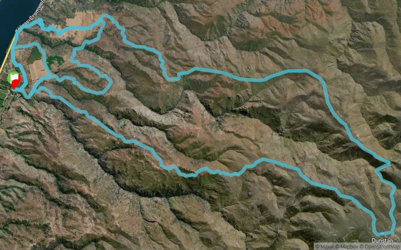
taking you from 200m above sea level (Start/finish) up over the top of Northburn Station at around 1660m. Total climb of 2600m
There will be plenty of marshals along key areas of the course. The course will be well marked with directional arrows and reflective tape. There will be one aid station about half way with nutrition and electrolyte supplements. There will only be a couple of fresh water re-fill positions (creeks) along the course so a water carrying capacity of about 2L per person is important. there will be some compulsory re-fill points.
This is a dry, hard, rocky course mostly run over high country 4WD tracks but also including some short sections of fence lines and sheep tracks. The weather can be ‘changeable’ so your minimum gear must be carried at all times.
En voir plus... En voir moins...

Départ
Distance
0 km
Altitude
222 m
D+
0 m
D-
0 m
51.2 km
2430 m
2420 m
Arrivée
Distance
51.2 km
Altitude
222 m
D+
2430 m
D-
2420 m
Cliquez sur un point d'intérêt pour l'afficher sur la carte
Avis et chronos
Ajouter une trace
Northburn 100 Miler 2016 - 50 km

Numéro de trace : 15217
Lien vers la trace :
https://tracedetrail.fr/fr/trace/15217
Connectez-vous pour insérer cette trace sur votre site web
 Trace de Trail