
K24 Trail Race 2021 - 24 km
ITRA
 20.5 km
1000 m
990 m
20.5 km
1000 m
990 m


GPX
1
PDF
Profil
Partager
3D
Favoris
Avis
J'aime
?rna na Koroškem (SI) ?rna na Koroškem (SI)
Kilomètre effort
Plus longue montée
Plus longue descente
30
770 m
460 m
Altitude max
Altitude min
Indice de qualité
1346 m
568 m
 1pt/9m
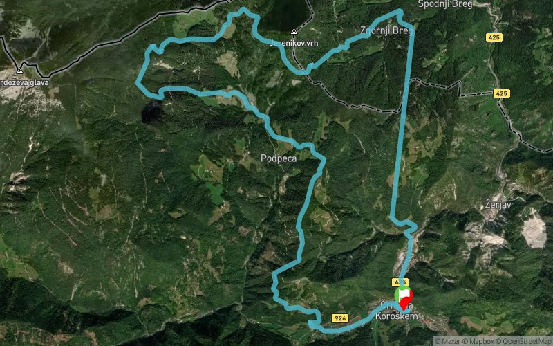
The race that goes from center of ?rna na Koroškem into biggest attraction of running thru abandoned tunnel in the underground. Highest point is Tomaževa ko?a at 1345 m above sea level. After descent to the settlement Mitnek, and just under 2 km of ascent to Pikovo, the prize will follow, as you will continue on our »Healing paths« with views on both side. After a rather steep last descent, you reach the settlement of Pristava and two kilometers of asphalt brings you to the finish in front of the cultural center ?rna.
En voir plus... En voir moins...
Trace créée par SPORTNO DRUSTVO K TWENTYFOUR
le 22/03/2021 (modifiée le 26/03/2021)
le 22/03/2021 (modifiée le 26/03/2021)

Départ
Distance
0 km
Altitude
581 m
D+
0 m
D-
0 m
20.5 km
1000 m
990 m
Arrivée
Distance
20.5 km
Altitude
581 m
D+
1000 m
D-
990 m
Cliquez sur un point d'intérêt pour l'afficher sur la carte
Avis et chronos
Ajouter une trace
K24 Trail Race 2021 - 24 km

Numéro de trace : 143724
Lien vers la trace :
https://tracedetrail.fr/fr/trace/143724
Connectez-vous pour insérer cette trace sur votre site web
 Trace de Trail