
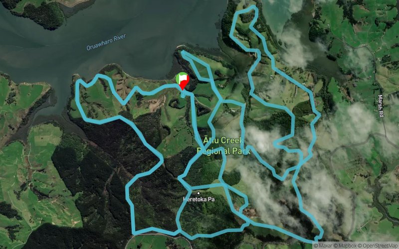
The Gazuntite 2018 - 34 km
ITRA
 34.1 km
1480 m
1480 m
34.1 km
1480 m
1480 m

J'aime
Favoris
Avis
Partager
GPX
4
PDF A4
PDF A0
Profil
Flyover
3D
Insérer
Passages
Wharehine (NZ) Wharehine (ND)
Kilomètre effort
Plus longue montée
Plus longue descente
48
160 m
130 m
Altitude max
Altitude min
Indice de qualité
167 m
4 m
 1pt/11m
The Gazuntite is a brand new trail run event created to replace The Hillary which has had to be cancelled for 2018 due to a r?hui placed on the Waitakere Ranges by local iwi Te Kawerau a Maki in order to prevent the continued spread of Kauri Dieback.
Choose from an 80km Ultra Run, 80km 2-3 person run relay, or a 34 or 16km run or walk.
Based at a new-ish Auckland Regional Park – Atiu Creek Farm was gifted to the Auckland Regional Council by Jackie and Pierre Chatelanat who wanted to ensure that all New Zealanders could enjoy access to the Kaipara Harbour, and that the cultural and heritage values of the area would be protected. And what a treat they left for all of us!
You’ll enjoy a mix of open farmland, gravel farm tracks, pine covered forestry trails, native bush, hills, some awesome views of the Kaipara Harbour and some hills!!
En voir plus... En voir moins...
Trace créée par LacticNZ
le 07/03/2018 (modifiée le 08/03/2018)
le 07/03/2018 (modifiée le 08/03/2018)

Départ
Distance
0 km
Altitude
15 m
D+
0 m
D-
0 m
34.1 km
1474 m
1474 m
Arrivée
Distance
34.1 km
Altitude
15 m
D+
1474 m
D-
1474 m
Cliquez sur un point d'intérêt pour l'afficher sur la carte
Avis et chronos
Ajouter une trace
The Gazuntite 2018 - 34 km

Numéro de trace : 54241
Lien vers la trace :
https://tracedetrail.fr/fr/trace/54241
Connectez-vous pour insérer cette trace sur votre site web
 Trace de Trail