
Manitou's Revenge 2018 - Ultramarathon and Relay
ITRA
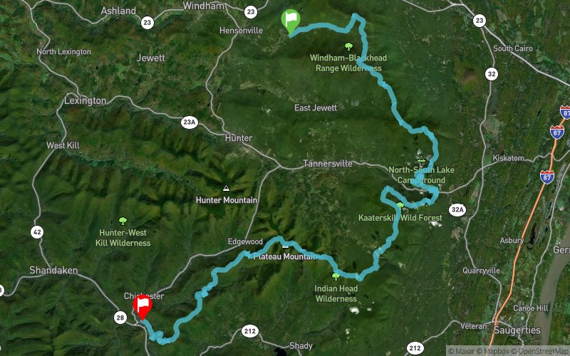
 83.6 km
4250 m
4560 m
83.6 km
4250 m
4560 m

J'aime
Favoris
Avis
Partager
GPX
10
PDF A4
PDF A0
Profil
Flyover
3D
Insérer
Passages
Maplecrest (US) Phoenicia (US)
Kilomètre effort
Plus longue montée
Plus longue descente
126
560 m
590 m
Altitude max
Altitude min
Indice de qualité
1192 m
186 m
 1pt/11m
This is a grueling, gnarly, nasty course with approximately 15,000 ft. of climbing, much of it rocky and precipitous. To be sure, there are some runnable sections, but you will more often find yourself hiking uphill or down, sometimes hand over hand. Expect this course to take you much longer than your average 50 miler. That’s why we are allowing 24 hrs. to complete this monster. Because of its remote and difficult nature, there will of necessity be a limited number of aid stations, only 9, and runners should be prepared to spend up to 3 or 4 hrs between aid stations. You will have to be reasonably self-sufficient. To make matters worse, the course gets progressively more difficult as you go along! And to top it all off, the average runner will have to tackle this hardest terrain in the dark.
En voir plus... En voir moins...
Trace créée par MANITOU'S REVENGE ULTRAMARATHON AND RELAY
le 11/01/2018
le 11/01/2018

Départ
Distance
0 km
Altitude
576 m
D+
0 m
D-
0 m
83.6 km
4249 m
4552 m
Arrivée
Distance
83.6 km
Altitude
273 m
D+
4249 m
D-
4552 m
Cliquez sur un point d'intérêt pour l'afficher sur la carte
Avis et chronos
Ajouter une trace
Manitou's Revenge 2018 - Ultramarathon and Relay

Numéro de trace : 50495
Lien vers la trace :
https://tracedetrail.fr/fr/trace/50495
Connectez-vous pour insérer cette trace sur votre site web
 Trace de Trail