
Wicklow Glacier Lakes 2018
ITRA
 41.6 km
1890 m
1890 m
41.6 km
1890 m
1890 m

J'aime
Favoris
Avis
Partager
GPX
16
PDF A4
PDF A0
Profil
Flyover
3D
Insérer
Passages
Wicklow (IE) Inconnu (IE)
Kilomètre effort
Plus longue montée
Plus longue descente
60
530 m
460 m
Altitude max
Altitude min
Indice de qualité
735 m
132 m
 1pt/18m
The race takes in some of the highest glacial lakes in Wicklow. The race traverses some of the wildest terrain in Wicklow. Solo runners should ensure they bring adequate clothing and food for all weathers as leg 2 in particular can be very difficult in mist. Participants must touch the water in each lake on their leg.
A mobile phone, hat, cagoule, map, and compass are compulsory kit. Bring food and water according to your needs for a run in tough mountain terrain. Solo runners must bring sufficient food and clothing protection for the whole race.
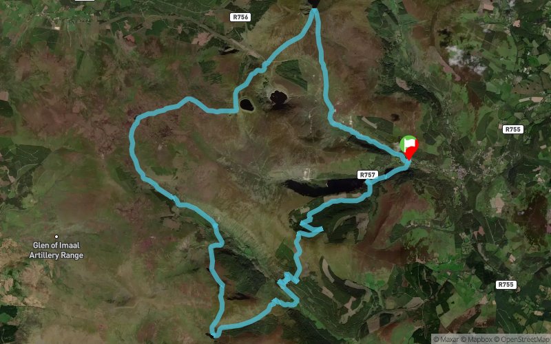
Leg 1 starts at the hotel in Glendalough and takes in Lough Ouler with the handover at the car park at the Wicklow Gap. The only part of the Wicklow Gap road that you can run on is the part on the St. Kevin's Way. Challenge: route choice and terrain.
Leg 2 takes in Lough Firrib and either of the Three Lakes with the handover at Glenmalure hostel. Challenge: navigation and tough terrain in middle of leg.
Leg 3 takes in Art's Lough and Kelly's Lough with the handover at Ballinafunshoge car park). Challenge: route choice and steep terrain.
Leg 4 takes in the Upper and Lower lakes in Glendalough with the finish at Glendalough hotel. Challenge: a runner's leg but route choice could win out!
En voir plus... En voir moins...

Départ
Distance
0 km
Altitude
137 m
D+
0 m
D-
0 m
41.6 km
1890 m
1890 m
Arrivée
Distance
41.6 km
Altitude
137 m
D+
1890 m
D-
1890 m
Cliquez sur un point d'intérêt pour l'afficher sur la carte
Avis et chronos
Ajouter une trace
Wicklow Glacier Lakes 2018

Numéro de trace : 48334
Lien vers la trace :
https://tracedetrail.fr/fr/trace/48334
Connectez-vous pour insérer cette trace sur votre site web
 Trace de Trail