
Caven 24
ITRA
 24.06 km
1734 m
1734 m

J'aime
Favoris
Avis
Partager
GPX
PDF A4
PDF A0
Profil
Flyover
3D
Insérer
Passages
Lokavec (SI) Lokavec (SI)
Types de terrain
Kilomètre effort
Plus longue montée
Plus longue descente
41
1080 m
520 m
Altitude max
Altitude min
Indice de qualité
1242 m
163 m
 1pt/9m
Caven 24 · 24 km · 1,734 m D+
Saturday 21 November 2026 · start and finish in Lokavec
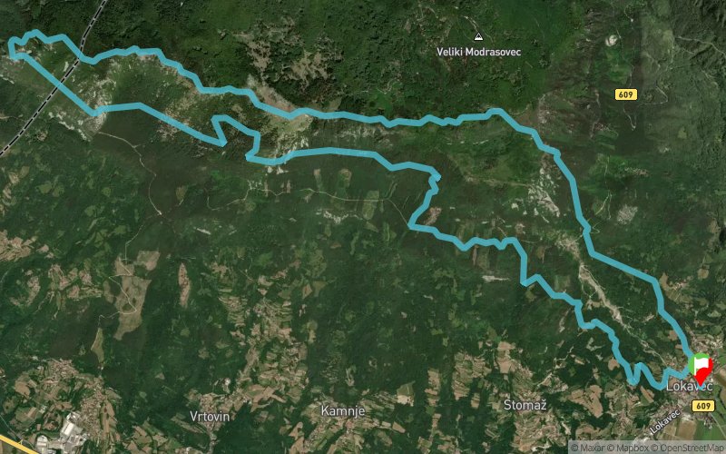
The real traverse of the summits above the Vipava Valley. From the meadows above Lokavec the trail climbs through the forest to Koča Antona Bavčerja on Čaven, and from there the race stays high: along the ridge to Kucelj, then west from one top to the next, over Veliki rob and Čaven and on to Sekulak, with the Vipava Valley below you all the way and the Karst and the Gulf of Trieste on the horizon.
From Sekulak the course turns back east, contouring the slopes beneath the ridge you have just run, and drops down to the finish in Lokavec.
Loop course: Lokavec – Koča Antona Bavčerja – Kucelj – Veliki rob – Čaven – Sekulak – Lokavec.
Full details: www.caven.run
En voir plus... En voir moins...


Štart / Start — Lokavec
Distance
0 km
Altitude
163 m
D+
0 m
D-
0 m
Base vie
2.4 km
422 m
0 m
Potok
Distance
2.4 km
Altitude
588 m
D+
422 m
D-
0 m
Eau
2 km
657 m
0 m
Koča Antona Bavčerja
Distance
4.5 km
Altitude
1244 m
D+
1079 m
D-
0 m
Ravitaillement
10.3 km
469 m
680 m
Kucelj
Distance
14.8 km
Altitude
1029 m
D+
1548 m
D-
680 m
Eau
9.3 km
186 m
1054 m
Cilj / Finish — Lokavec
Distance
24.1 km
Altitude
163 m
D+
1734 m
D-
1734 m
Base vie
Cliquez sur un point d'intérêt pour l'afficher sur la carte
Avis et chronos
Attention ! Ce parcours est accessible uniquement le jour de la compétition
Ajouter une trace
Caven Run Caven 24

Numéro de trace : 363994
Lien vers la trace :
https://tracedetrail.fr/fr/trace/363994
Connectez-vous pour insérer cette trace sur votre site web
 Trace de Trail