
Benasque Trail 2 Heaven
ITRA
 35.95 km
1604 m
2215 m
35.95 km
1604 m
2215 m


J'aime
Favoris
Avis
Partager
GPX
4
PDF A4
PDF A0
Profil
Flyover
3D
Insérer
Passages
Llanos del Hospital (ES) Benasque (ES)
Kilomètre effort
Plus longue montée
Plus longue descente
51
640 m
610 m
Altitude max
Altitude min
Indice de qualité
2377 m
1134 m
 1pt/6m
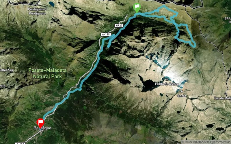
TRAIL 2 HEAVEN WITHOUT LEAVING THE BENASQUE VALLEY
Enjoy the Trail 2 Heaven without leaving the Benasque Valley. Starting at the foot of Mount Aneto, in the Nordic ski resort of Los Llanos del Hospital, this route covers 35,3 km with 1650 m of elevation gain. Follow the path to Aneto, visit the Villamorta lakes, the Aigualluts waterfall, the Renclusa refuge, and skirt the border with France. Finish in the town of Benasque.
En voir plus... En voir moins...

Start
Distance
0 km
Altitude
1746 m
D+
0 m
D-
0 m
10:30
36 km
1604 m
2215 m
Finish
Distance
36 km
Altitude
1135 m
D+
1604 m
D-
2215 m
Village
Cliquez sur un point d'intérêt pour l'afficher sur la carte
Avis et chronos
Ajouter une trace
Trail 2 Heaven - Benasque Trail 2 Heaven

Numéro de trace : 329522
Lien vers la trace :
https://tracedetrail.fr/fr/trace/329522
Connectez-vous pour insérer cette trace sur votre site web
 Trace de Trail