
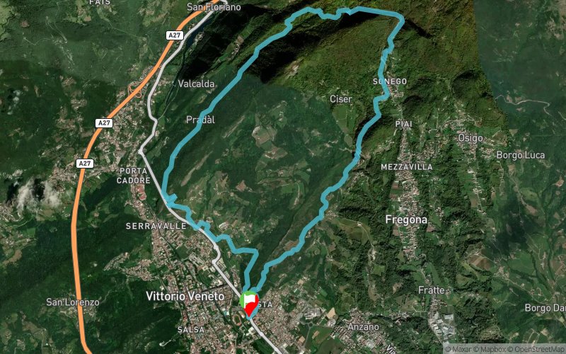
Madruk Trail 17Km
ITRA
 16.95 km
931 m
931 m
16.95 km
931 m
931 m

J'aime
Favoris
Avis
Partager
GPX
71
PDF A4
PDF A0
Profil
Flyover
3D
Insérer
Passages
Vittorio Veneto (IT) Vittorio Veneto (IT)
Kilomètre effort
Plus longue montée
Plus longue descente
26
390 m
490 m
Altitude max
Altitude min
Indice de qualité
757 m
125 m
 1pt/6m
The Madruk Trail is a race of 27 km length and approximately 1.800mD+, in Vittorio Veneto (Italy). Madruk Trail provides a challenging route in Vittorio Veneto forests, during the beautiful spring colors of Venetian Pre-Alps. This is a medium technical trail (due to rocky areas). The trail surface varies from narrow forest trail to wide fire road, gravel, dirt, and paved roads. Several up and downhills are along the course. Participating to Madruk Trail 27 Km you earn 2 points ITRA . There is also a shorter version called Madruk Trail Short which is a race of 16 Km length and total ascent about 930 mt - 1 point ITRA. Madruk Trail is "20k M Qualifier" for UTMB
En voir plus... En voir moins...

Départ
Distance
0 km
Altitude
125 m
D+
0 m
D-
0 m
09:00
17 km
931 m
931 m
Arrivée
Distance
17 km
Altitude
125 m
D+
931 m
D-
931 m
Cliquez sur un point d'intérêt pour l'afficher sur la carte
Avis et chronos
Ajouter une trace
Madruk Trail Madruk Trail 17Km

Numéro de trace : 329324
Lien vers la trace :
https://tracedetrail.fr/fr/trace/329324
Connectez-vous pour insérer cette trace sur votre site web
 Trace de Trail