
Black Canyon Ultras 2017 - 60K
ITRA
 59.4 km
750 m
1290 m
59.4 km
750 m
1290 m

J'aime
Favoris
Avis
Partager
GPX
12
PDF A4
PDF A0
Profil
Flyover
3D
Insérer
Passages
Mayer (US) Black Canyon City (US)
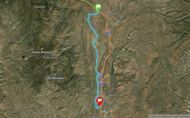
Kilomètre effort
Plus longue montée
Plus longue descente
66
100 m
520 m
Altitude max
Altitude min
Indice de qualité
1276 m
634 m
 1pt/15m
Experience the beauty of winding Sonoran Desert trails in the shadow of the Bradshaw Mountains. The course is point-to-point with net elevation loss.. but do not be fooled: this is a tough and taxing course with the majority of elevation gain coming the 2nd half. Challenge yourself this February 13th and join us for the 3rd annual Black Canyon 100K! The course runs along the non-motorized Black Canyon Trail (a National Recreation Trail) featuring a mixture of single track trail, jeep roads, and pieces of an old stagecoach route. The Black Canyon Trail is located on Bureau of Land Management land and is overseen by the Black Canyon Trail Coalition. New this year is a point to point 60K starting at Mayer High School and finishing at Black Canyon City.
En voir plus... En voir moins...

Départ
Distance
0 km
Altitude
1216 m
D+
0 m
D-
0 m
59.4 km
744 m
1282 m
Arrivée
Distance
59.4 km
Altitude
680 m
D+
744 m
D-
1282 m
Cliquez sur un point d'intérêt pour l'afficher sur la carte
Avis et chronos
Ajouter une trace
Black Canyon Ultras 2017 - 60K

Numéro de trace : 28866
Lien vers la trace :
https://tracedetrail.fr/fr/trace/28866
Connectez-vous pour insérer cette trace sur votre site web
 Trace de Trail