
Northburn 100 Miler 2016 - 100 km
ITRA
 101.8 km
5050 m
5050 m
101.8 km
5050 m
5050 m

J'aime
Favoris
Avis
Partager
GPX
12
PDF A4
PDF A0
Profil
Flyover
3D
Insérer
Passages
Cromwell (NZ) Inconnu (NZ)
Kilomètre effort
Plus longue montée
Plus longue descente
152
1620 m
1090 m
Altitude max
Altitude min
Indice de qualité
1661 m
149 m
 1pt/14m
Yes! The 100k is all on for 2016!!
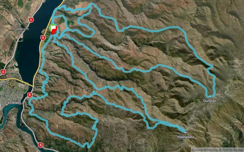
Click the maps below to view as Jpegs or down load the google earth files from the Route Profiles tab above. The 100k course covers 2 maps, each loop starts and finishes in the same place - great to catch up with your supporters!
The first 50km loop take you from 200m above sea level (Start/finish) up near the most central point in New Zealand at around 1660m (2600m vertical climb). The second 'loop' is another 50km loop with a climb of 3750m.
There will be plenty of marshals along key areas of the course. The course will be well marked with directional arrows, plastic poles and reflective tape at night.
There will be two aid stations with nutrition and electrolyte supplements, each one about half way around each loop. You will also be coming back through the start/finish area at the 50k mark you will be able to pick up your personal refreshments/gear as required. There will be multiple fresh water re-fill positions (creeks) along the course so a water carrying capacity of about 2L per person should be adequate there will be some compulsory re-fill points.
This is a dry, hard, rocky course mostly run over high country 4WD tracks but also including some short sections of fence lines and sheep tracks. The weather can be 'changeable' so your minimum gear must be carried at all times.
En voir plus... En voir moins...

Départ
Distance
0 km
Altitude
222 m
D+
0 m
D-
0 m
101.8 km
5050 m
5050 m
Arrivée
Distance
101.8 km
Altitude
222 m
D+
5050 m
D-
5050 m
Cliquez sur un point d'intérêt pour l'afficher sur la carte
Avis et chronos
Ajouter une trace
Northburn 100 Miler 2016 - 100 km

Numéro de trace : 15218
Lien vers la trace :
https://tracedetrail.fr/fr/trace/15218
Connectez-vous pour insérer cette trace sur votre site web
 Trace de Trail