
Transylvania Trail Traverse 2015 - Vlad Tepes 52K
ITRA
 50.6 km
3636 m
3629 m
50.6 km
3636 m
3629 m


J'aime
Favoris
Avis
Partager
GPX
88
PDF A4
PDF A0
Profil
Flyover
3D
Insérer
Passages
Simon (RO) 0 (0)
Kilomètre effort
Plus longue montée
Plus longue descente
86
1688 m
1195 m
Altitude max
Altitude min
Indice de qualité
2486 m
951 m
 1pt/33m
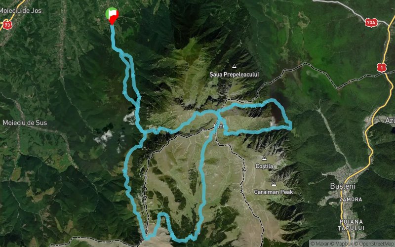
Vlad the Impaler trail begins at the Bran ski slope where also the finish line will be, then continues on a forestry road. Soon we leave the road and begin a steep climb following the single trail path through the wild forest.
A grassy meadow (Saua Polite) is the sign that the first sustained climb is over. Next is a quick descent that leads us shortly to the entrance of the Hole Valley (V. Gaura). Devil’s Mill Waterfall (Cascada Moara Dracului) marks the beginning of a long and supported climb with technical passages, chains and spectacular walls of cliffs. We cross the Catunasul River, the last source of water for the next 5 km.
We leave behind the forest at an altitude of 1800 m entering the alpine meadow. Then we reach an imposing glacial cirque, located at an altitude of 2200 m. Only 300 m level difference separates us from the highest point of the trail, the Omu Peak. At this point we can also benefit of the Omu Hut shelter point (Cabana Omu 2507 m).
It follows a 6 km long speeding downhill, called the Stag Valley (V. Cerbului). At the end of the valley the trail follows a contour line with little ups and downs that leads us to the next glacial valley of the trail. It’s Miller Valley (V. Morarului) this time, a path with unique views and passages, unmarked for tourists. We quickly win altitude again in the places frequented more often by black mountain goats than by people. Here and there climb gets technical and we use our hands to advance. With a length of 3.5 km, Miller Valley (V. Morarului) it`s ending in the alpine plateau.
We reach for the second time the cottage Omu (Cabana Omu) and continue on to a more welcoming path from here, Ialomita Valley (V. Ialomita), 6 km long in easy descent. Leaving the cool air from over 2000 m we descend beneath the cable car and reach The Cave (Pestera) area.
Here optional, 50m from the trail we can see a monastery built in a cave (Schitul Pestera).
Once out of the cave, 500 m further we turn west on the amazing Valley of Horoabei (V. Horoabei). Waterfalls, tunnels, stairs, chains will delight and provoke us equally. After clearing all obstacles we get out in the alpine and follow the path that leads to the place called Strunga (Saua Strunga 1909 m). Passing it we are in the western part of the massif.
We pass a couple of sheepfolds and we are getting closer to finish. From Polite clearing (Saua Polite) we go straight ahead on red cross marking, which will guide us to the finish line of the 52 km long track with an elevation gain of 4000 m.
En voir plus... En voir moins...
Trace créée par mihaitruly
le 21/08/2015 (modifiée le 20/10/2015)
le 21/08/2015 (modifiée le 20/10/2015)

Bran, Brasov
Distance
0 km
Altitude
928 m
D+
0 m
D-
0 m
50.6 km
3636 m
3629 m
Arrivée
Distance
50.6 km
Altitude
928 m
D+
3636 m
D-
3629 m
Cliquez sur un point d'intérêt pour l'afficher sur la carte
Avis et chronos
Ajouter une trace
Transylvania Trail Traverse 2015 - Vlad Tepes 52K

Numéro de trace : 10770
Lien vers la trace :
https://tracedetrail.fr/fr/trace/10770
Connectez-vous pour insérer cette trace sur votre site web
 Trace de Trail