
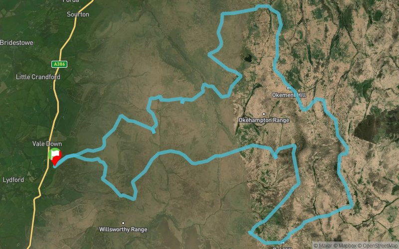
Cranmere Pool - Cut Hill - Hangingstone - High Willhays
ROUTE TESTED BY THE AUTHOR
 43 km
1640 m
1640 m
43 km
1640 m
1640 m
GPX
PDF
Profile
Share
3D
Favorites
Reviews
1 Like
Lydford (GB) Lydford (GB)
Effort kilometer
Longest ascent
Longest descent
59
180 m
320 m
Max. elevation
Min. elevation
Quality index
612 m
280 m
 1pt/8m
Start
Distance
0 km
Altitude
280 m
D+
0 m
D-
0 m
43 km
1640 m
1640 m
Finish
Distance
43 km
Altitude
280 m
D+
1640 m
D-
1640 m
Click on a point of interest to display it on the map
Reviews and times
trailtom2019/08/23
2019/08/22 08:39:00
2019/08/22 08:39:00
The Dartmoor 551s - 17 of the 18 Dartmoor 550s (left out Cosdon HIll at 550m). Predominantly bog traversing east to west but then military tracks aided the west to east. Some hard sections in deep brush.
Add a track
Cranmere Pool - Cut Hill - Hangingstone - High Willhays

Track number : 95630
Link to track :
https://tracedetrail.fr/en/trace/95630
Log in to insert this track on your website
 Trace de Trail