Show the map
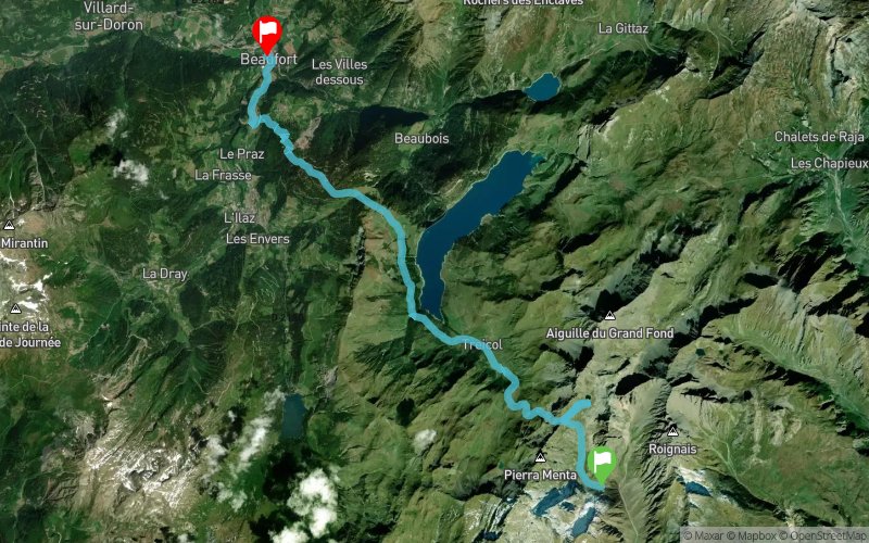
La Balme - Lac de Presset - Lac de Roselend - Col du Pré


18.2 km
676 m
1957 m


Points of Interest table
Accum. | Intermediary | |||||||
---|---|---|---|---|---|---|---|---|
POI | Description | Alt. | Dist. | D+ | D- | Dist. | D+ | D- |
Trace n°9431
Ascent threshold : 3 m Distance threshold : 30 m Smoothing : Yes Origin of altitudes : MNT Aster GDEM
Crossing
Dominant terrain : Footpath
Max alti. : 2513 m
Avg alti. : 1726 m
Min alti. : 735 m
Longest ascent : 495 m
Longest descent : 1958 m
Route completed by the author : nc
Dominant terrain : Footpath
Max alti. : 2513 m
Avg alti. : 1726 m
Min alti. : 735 m
Longest ascent : 495 m
Longest descent : 1958 m
Route completed by the author : nc
Elevation profile

Their last tracks
More tools
Create a new roadbook page
Carte à la Carte IGN
Map and track on your website
Warning ! When you insert a Trace de Trail map on your website, you agree not to hide any element of the module (links to Trail Trail or Trail Connect banner)
Add a realisation
Validate
Add a realisation to share your chrono and describe the conditions that you encountered during you trail running !
Add a comment
Validate
Nearby tracks
0.1 km Ref. de la Balme - Col du Grand Fond - Col des Fours - Col du Bonhomme - Ref. du Plan de la Lai
35.1 km
2600 m
2790 m
Les Chapelles (73)
0.1 km Ref. de la Balme - Col du Grand Fond - Col du Bresson - St-Guérin
11.2 km
690 m
1100 m
Les Chapelles (73)
0.1 km Ref. de la Balme - Passeur de la Mintaz - Lac d'Amour - Ref. de la Coire
8.2 km
720 m
670 m
Les Chapelles (73)
0.1 km Ref. de la Balme - Col de Bresson - Col du Coin - Ref. de la Coire - Laval
14.8 km
1040 m
1390 m
Les Chapelles (73)
2.7 km Ref de Presset - La Pierra Menta - Ref.du PLan de la Lai
12.3 km
510 m
1200 m
Les Chapelles (73)
3.3 km Lac d'Amour - La Pierra Menta - Cormet de Roselend - Col de la Sauce - Col du Bonhomme
23.5 km
1550 m
1490 m
Granier (73)
4.3 km St-Guérin - Ref. de presset - Col du Bresson - Col du Mont Rosset
16.9 km
1350 m
1350 m
vallée de forant (73)
5.7 km Treicol - Presset - Col du Coin - Lac d'Amour - Ref. de Presset
15.6 km
1170 m
1160 m
Beaufort (73)
5.8 km Lac d'Amour - La Pierra Menta - Col du Bresson - Brèche de Parozan
12.4 km
1170 m
1170 m
Beaufort (73)
6.8 km Col du Mont Rosset - Col du Bresson - Refuge de Presset
9.4 km
1440 m
340 m
La Côte-d'Aime (73)
6.8 km Pont de la Gitte - Refuge de Presset - Col du Coin - Col de la Grande Combe
28.2 km
1880 m
1880 m
La Côte-d’Aime (73)
Show the infos
Add a track