Show the map
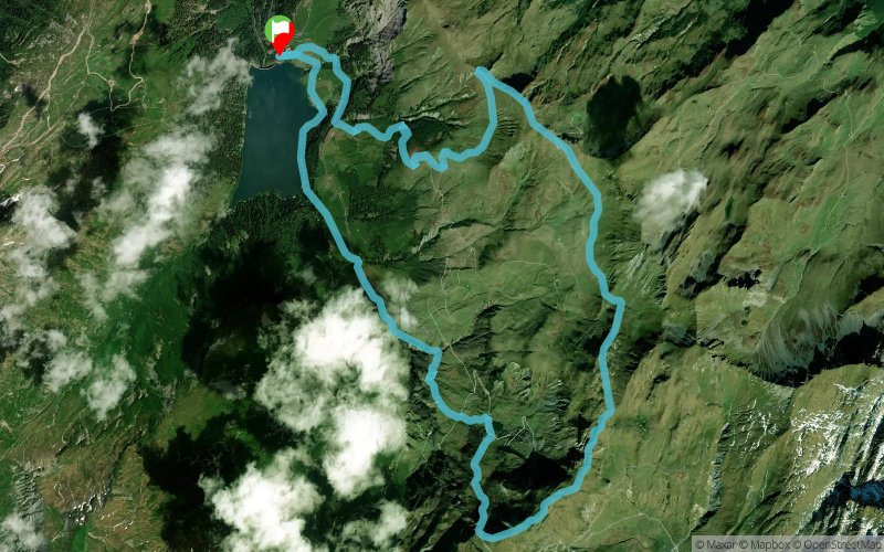
Lac de St-Guérin - Croix du Berger - Col du Couvercle


13.3 km
900 m
900 m

Points of Interest table
Accum. | Intermediary | |||||||
---|---|---|---|---|---|---|---|---|
POI | Description | Alt. | Dist. | D+ | D- | Dist. | D+ | D- |
Trace n°92256
Ascent threshold : 3 m Distance threshold : 30 m Smoothing : Yes Origin of altitudes : MNT Aster GDEM
Loop
Dominant terrain : Footpath
Max alti. : 2307 m
Avg alti. : 1943 m
Min alti. : 1560 m
Longest ascent : 740 m
Longest descent : 750 m
Route completed by the author : Yes
Dominant terrain : Footpath
Max alti. : 2307 m
Avg alti. : 1943 m
Min alti. : 1560 m
Longest ascent : 740 m
Longest descent : 750 m
Route completed by the author : Yes
Elevation profile

Their last tracks
Le Dèsert en Valjoufrey - La Chappelle en Valjoufrey - Valsenestre - Côte Belle
21.8 km
1510 m
1510 m
Valjouffrey (38)
More tools
Create a new roadbook page
Carte à la Carte IGN
Map and track on your website
Warning ! When you insert a Trace de Trail map on your website, you agree not to hide any element of the module (links to Trail Trail or Trail Connect banner)
Add a realisation
Validate
Add a realisation to share your chrono and describe the conditions that you encountered during you trail running !
Add a comment
Validate
Nearby tracks
0.1 km Lac de St-Guérin - Cormet d'Arêches - La Pierra Menta - Cormet de Roselend
20.9 km
1450 m
1040 m
Beaufort (73)
0.2 km Lac de St Guérin - Pierra Menta - Col du Bresson - Col du Couvercle
25 km
1766 m
1751 m
Beaufort (73)
1.8 km Ref. de l'Alpage - Col de la Bâthie - Col des Lacs - Molliessoulaz
21.2 km
910 m
2340 m
Beaufort (73)
1.8 km Ref. de l'Alpage - Lac de St-Guérin - Cormet d'Arêches - La Pierra Menta - Ref. de la Balme
16.7 km
1240 m
1220 m
Beaufort (73)
1.8 km Ref. de l'Alpage - Lac de St-Guérin - Lac des Fées - Col du Coin - La Pierra Menta
16.7 km
1240 m
1220 m
Beaufort (73)
4.1 km Les Quéfins - Le Grand Mont - Lac de St-Guérin - Cormet d'Arêches - Lac d'Amour
24.2 km
2400 m
1420 m
Beaufort (73)
5.8 km Roche Plane - Mirantin - Grande Journée - Col de la Bâthie
25.9 km
2460 m
2460 m
Beaufort (73)
5.8 km Arêches - Plan Villard - Le Planay - Ref. des Arolles - Tête de Cuvy - Roche Pastire
40.6 km
3210 m
3210 m
Beaufort (73)
Show the infos
Add a track