
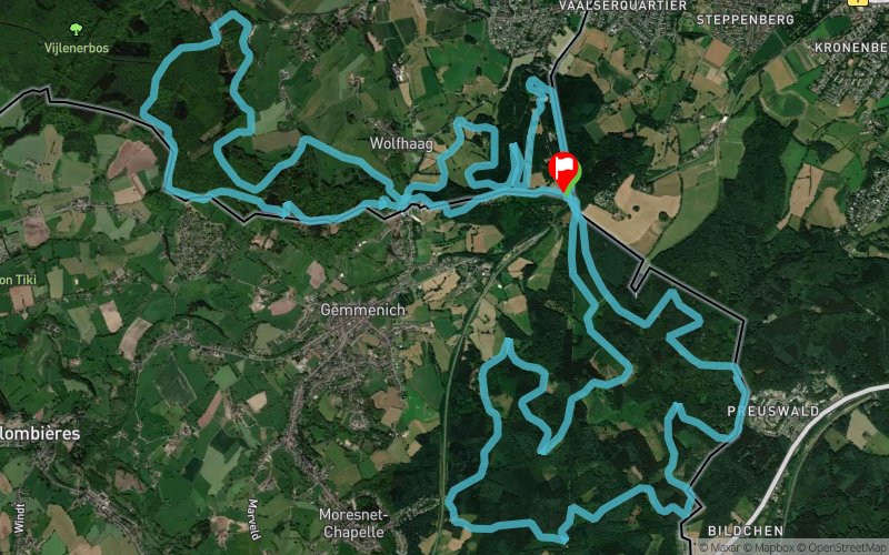
Drielandenpunt Trail 2023 - 28km
 28.6 km
910 m
910 m
28.6 km
910 m
910 m
06/02/2022
GPX
PDF
Profile
Share
3D
Favorites
Reviews
Like
Vaals (NL) Vaals (NL)
Effort kilometer
Longest ascent
Longest descent
37
90 m
80 m
Max. elevation
Min. elevation
Quality index
357 m
222 m
 1pt/17m

Start
Distance
0 km
Altitude
326 m
D+
0 m
D-
0 m
13.7 km
364 m
364 m
Ravito
Distance
13.7 km
Altitude
325 m
D+
364 m
D-
364 m
0 km
0 m
0 m
Ravito
Distance
13.7 km
Altitude
325 m
D+
364 m
D-
364 m
8.6 km
308 m
384 m
Ravito
Distance
22.4 km
Altitude
249 m
D+
672 m
D-
748 m
6.1 km
231 m
162 m
Finish
Distance
28.6 km
Altitude
321 m
D+
903 m
D-
910 m
Click on a point of interest to display it on the map
Reviews and times
Warning ! This track is only accessible on the day of the competition
Add a track
Drielandenpunt Trail 2023 - 28km

Track number : 90677
Link to track :
https://tracedetrail.fr/en/trace/90677
Log in to insert this track on your website
 Trace de Trail