Show the map
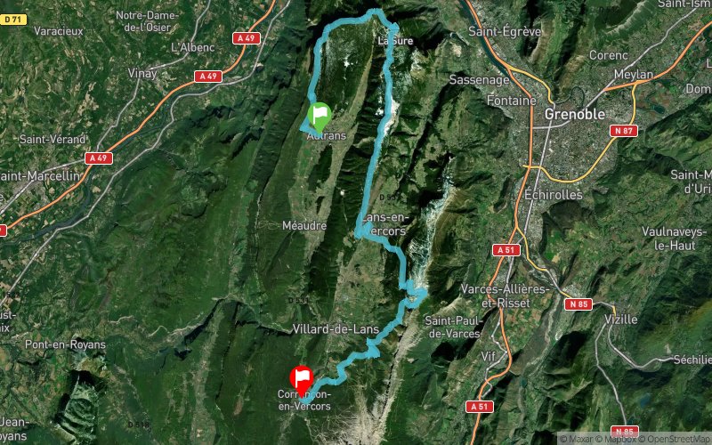
Bec de l'Orient - La Sure - Charande - Pic St-Michel - Les Glovettes


53.7 km
2930 m
2870 m


Points of Interest table
Accum. | Intermediary | |||||||
---|---|---|---|---|---|---|---|---|
POI | Description | Alt. | Dist. | D+ | D- | Dist. | D+ | D- |
Trace n°85363
Ascent threshold : 3 m Distance threshold : 30 m Smoothing : No Origin of altitudes : MNT Aster GDEM
Crossing
Dominant terrain : Footpath
Max alti. : 1929 m
Avg alti. : 1424 m
Min alti. : 768 m
Longest ascent : 1110 m
Longest descent : 810 m
Route completed by the author : No
Dominant terrain : Footpath
Max alti. : 1929 m
Avg alti. : 1424 m
Min alti. : 768 m
Longest ascent : 1110 m
Longest descent : 810 m
Route completed by the author : No
Elevation profile

Their last tracks
Croix du Liorin - Villard-de-Lans - Col de la Croix Chabaud - Méaudre - Rencurel
38.9 km
2400 m
2460 m
Corrençon-en-Vercors (38)
More tools
Create a new roadbook page
Carte à la Carte IGN
Map and track on your website
Warning ! When you insert a Trace de Trail map on your website, you agree not to hide any element of the module (links to Trail Trail or Trail Connect banner)
Add a realisation
Validate
Add a realisation to share your chrono and describe the conditions that you encountered during you trail running !
Add a comment
Validate
Nearby tracks
0.1 km Pas de Bellecombe - St-Nizier-du-Moucherotte - Vallon du Bruyant
22 km
1200 m
1230 m
Autrans (38)
0.3 km Ref. de Gève - Pas du Mortier - Plénouze - Charande - Bellecombe
26.8 km
1000 m
990 m
Autrans (38)
Show the infos
Add a track