
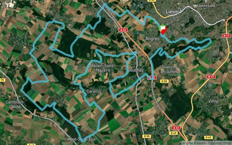
Grand Trail Nocturne des hauts de France 2024 - 61 km
 60.7 km
1620 m
1620 m
60.7 km
1620 m
1620 m

26/10/2024
GPX
946
PDF
Profile
Share
3D
Favorites
Reviews
Like
3
Angres (62) Angres (62)
Effort kilometer
Longest ascent
Longest descent
76
110 m
100 m
Max. elevation
Min. elevation
Quality index
195 m
31 m
 1pt/23m
www.gtnhautsdefrance.fr
Track created by sylvainmichel
le 2018/12/16 (modified on 2024/04/03)
le 2018/12/16 (modified on 2024/04/03)


Start
Distance
0 km
Altitude
63 m
D+
0 m
D-
0 m
18.2 km
487 m
399 m
R1
Distance
18.2 km
Altitude
153 m
D+
487 m
D-
399 m
11.5 km
251 m
275 m
R2
Distance
29.8 km
Altitude
127 m
D+
738 m
D-
674 m
10.5 km
257 m
219 m
Notre dame de Lorette
Distance
40.3 km
Altitude
165 m
D+
995 m
D-
893 m
11.4 km
346 m
445 m
R4
Distance
51.7 km
Altitude
66 m
D+
1341 m
D-
1338 m
8.9 km
279 m
282 m
Finish
Distance
60.7 km
Altitude
63 m
D+
1620 m
D-
1620 m
Click on a point of interest to display it on the map
Reviews and times
Add a track
Grand Trail Nocturne des Hauts de France Grand Trail Nocturne des hauts de France 2024 - 61 km

Track number : 74863
Link to track :
https://tracedetrail.fr/en/trace/74863
Log in to insert this track on your website
 Trace de Trail