Show the map
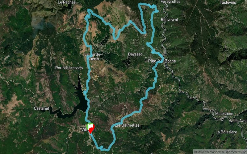
L'Esclayrade - Pied de Borne - St-Jean-Chazorne - La Guarde-Guérin - Lac de Villefort


33.9 km
1340 m
1340 m

Points of Interest table
Accum. | Intermediary | |||||||
---|---|---|---|---|---|---|---|---|
POI | Description | Alt. | Dist. | D+ | D- | Dist. | D+ | D- |
Trace n°62459
Ascent threshold : 3 m Distance threshold : 30 m Smoothing : Yes Origin of altitudes : MNT Aster GDEM
Loop
Dominant terrain : Footpath
Max alti. : 923 m
Avg alti. : 733 m
Min alti. : 316 m
Longest ascent : 940 m
Longest descent : 570 m
Route completed by the author : No
Dominant terrain : Footpath
Max alti. : 923 m
Avg alti. : 733 m
Min alti. : 316 m
Longest ascent : 940 m
Longest descent : 570 m
Route completed by the author : No
Elevation profile

Their last tracks
Porte de la Vaunage - Combe Birounet - Montpezat - Serre Mouressipe - Malascombe
20.2 km
580 m
580 m
Montpezat (30)
Jaujac - Rocher de Courcoussat - Serre de la Pierre Plantée - Rocher d'Abraham
54 km
3140 m
3140 m
Saint-Cirgues-de-Prades (07)
Les Hugous - Col du Merle - Mont Aigu - Col de la Croix Bauzon - Jaujac
57.6 km
2510 m
2510 m
Saint-Cirgues-de-Prades (07)
Montagne de la Fage - Le Laquet - Montagne des Cagnasses
30.2 km
1390 m
1390 m
La Cadière-et-Cambo (30)
More tools
Create a new roadbook page
Carte à la Carte IGN
Map and track on your website
Warning ! When you insert a Trace de Trail map on your website, you agree not to hide any element of the module (links to Trail Trail or Trail Connect banner)
Add a realisation
Validate
Add a realisation to share your chrono and describe the conditions that you encountered during you trail running !
Add a comment
Validate
Nearby tracks
0.5 km Cubières - Orcières - Florac - Montagne du Bouges - Le Bousquillou
116.3 km
4330 m
4330 m
Villefort (48)
4.4 km Castanet - Plo de la Voulp - Lac de Villefort - Le Rachas - Le Garde-Guérin
39 km
1470 m
1430 m
Pourcharesses (48)
13.5 km Le Roure - La Garde-Guérin - Lac de Villefort - Pourcharesses
28.5 km
1260 m
1250 m
Prévenchères (48)
16.9 km Pont de Maret - Ruisseau de la Pudissine - Le Mas de la Barque - Nojaret
23.7 km
1160 m
1160 m
Vialas (48)
18.0 km Chazalette - Croix de Bancillon - Malbosquet - Brahic - Naves
27.2 km
1770 m
1770 m
Gravières (07)
19.1 km Les Alauzas - La Croix de Bancillon - Le Serre de Barre - Les Bergères
7.2 km
600 m
600 m
Chambonas (07)
20.7 km Les Siroliers - Champmajour - St-jean-de-Pourcharesse - Thinés - Malarce
34.9 km
1620 m
1620 m
Saint-Pierre-Saint-Jean (07)
21.0 km Le Bleymard - Sommet de Finiels - Montagne du Bouges - Florac - St-Germain-de-Calberte
123 km
3690 m
4650 m
Chasseradès (48)
Show the infos
Add a track