
Manitou's Revenge 2018 - Ultramarathon and Relay
ITRA
 83.6 km
4250 m
4560 m
83.6 km
4250 m
4560 m

GPX
9
PDF
Profile
Share
3D
Favorites
Reviews
Like
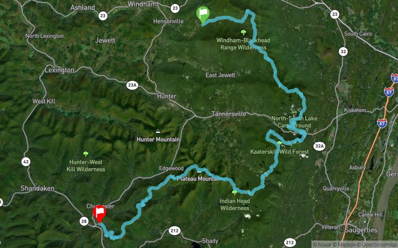
Maplecrest (US) Phoenicia (US)
Effort kilometer
Longest ascent
Longest descent
126
560 m
590 m
Max. elevation
Min. elevation
Quality index
1192 m
186 m
 1pt/11m
This is a grueling, gnarly, nasty course with approximately 15,000 ft. of climbing, much of it rocky and precipitous. To be sure, there are some runnable sections, but you will more often find yourself hiking uphill or down, sometimes hand over hand. Expect this course to take you much longer than your average 50 miler. That’s why we are allowing 24 hrs. to complete this monster. Because of its remote and difficult nature, there will of necessity be a limited number of aid stations, only 9, and runners should be prepared to spend up to 3 or 4 hrs between aid stations. You will have to be reasonably self-sufficient. To make matters worse, the course gets progressively more difficult as you go along! And to top it all off, the average runner will have to tackle this hardest terrain in the dark.
En voir plus... En voir moins...
Track created by MANITOU'S REVENGE ULTRAMARATHON AND RELAY
le 2018/01/11
le 2018/01/11

Start
Distance
0 km
Altitude
576 m
D+
0 m
D-
0 m
83.6 km
4249 m
4552 m
Finish
Distance
83.6 km
Altitude
273 m
D+
4249 m
D-
4552 m
Click on a point of interest to display it on the map
Reviews and times
Add a track
Manitou's Revenge 2018 - Ultramarathon and Relay

Track number : 50495
Link to track :
https://tracedetrail.fr/en/trace/50495
Log in to insert this track on your website
 Trace de Trail