
L'Echappee Belle 2018 - Parcours des Crêtes
ITRA
 56.9 km
4070 m
4210 m
56.9 km
4070 m
4210 m

01/09/2018
GPX
579
PDF
Profile
Share
3D
Favorites
Reviews
Like
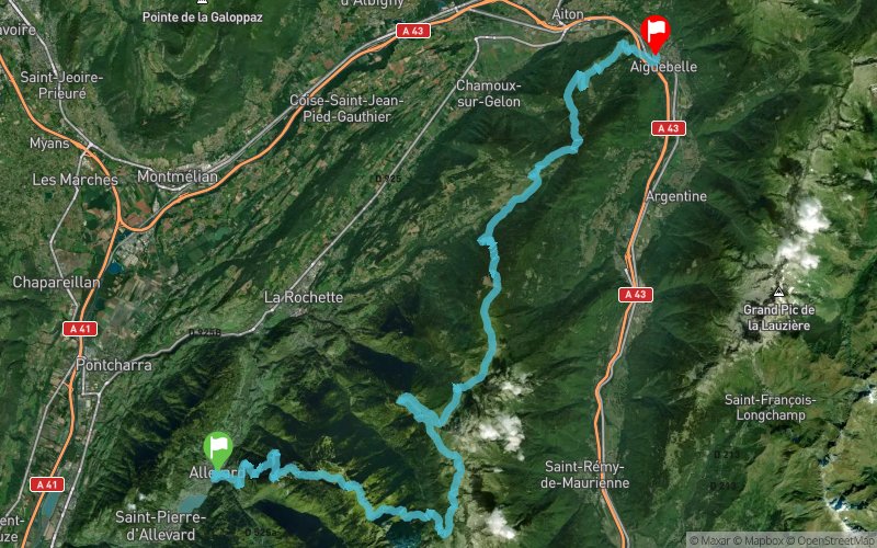
Allevard (38) Aiguebelle (73)
Effort kilometer
Longest ascent
Longest descent
97
1700 m
1150 m
Max. elevation
Min. elevation
Quality index
2270 m
318 m
 1pt/29m
Track created by L'Echappée Belle
le 2017/12/12 (modified on 2018/02/01)
le 2017/12/12 (modified on 2018/02/01)


Allevard
Distance
0 km
Altitude
464 m
D+
0 m
D-
0 m
10 km
1238 m
59 m
Super collet
Distance
10 km
Altitude
1644 m
D+
1238 m
D-
59 m
2.3 km
437 m
0 m
Sommet des Plagnes
Distance
12.3 km
Altitude
2083 m
D+
1675 m
D-
59 m
1.3 km
16 m
139 m
Col de Claran
Distance
13.7 km
Altitude
1958 m
D+
1691 m
D-
198 m
0.8 km
0 m
167 m
Refuge de Claran
Distance
14.5 km
Altitude
1791 m
D+
1691 m
D-
365 m
1.2 km
49 m
149 m
Chalet de la Balme
Distance
15.7 km
Altitude
1692 m
D+
1740 m
D-
514 m
1 km
5 m
171 m
Intersection
Distance
16.7 km
Altitude
1524 m
D+
1745 m
D-
685 m
0.2 km
0 m
54 m
Passerelle du Bens
Distance
17 km
Altitude
1472 m
D+
1745 m
D-
739 m
2 km
477 m
49 m
Refuge des Férices
Distance
19 km
Altitude
1900 m
D+
2222 m
D-
788 m
2.5 km
449 m
97 m
Intersection crête des férices
Distance
21.6 km
Altitude
2252 m
D+
2671 m
D-
885 m
0.3 km
18 m
12 m
Col d'Arpingon
Distance
21.9 km
Altitude
2259 m
D+
2689 m
D-
897 m
0.9 km
37 m
156 m
Sous col de la frêche
Distance
22.8 km
Altitude
2139 m
D+
2726 m
D-
1053 m
1.6 km
12 m
293 m
Refuge de la Perrière
Distance
24.5 km
Altitude
1855 m
D+
2738 m
D-
1346 m
2.3 km
27 m
157 m
Val Pelouse
Distance
26.8 km
Altitude
1724 m
D+
2765 m
D-
1503 m
1.7 km
295 m
10 m
Sommet des crêtes
Distance
28.6 km
Altitude
2014 m
D+
3060 m
D-
1513 m
0.4 km
5 m
31 m
Col de la Perche
Distance
29.1 km
Altitude
1984 m
D+
3065 m
D-
1544 m
1.8 km
0 m
355 m
Source du Gargotton
Distance
30.9 km
Altitude
1629 m
D+
3065 m
D-
1899 m
1.3 km
346 m
5 m
Col de la Perche
Distance
32.3 km
Altitude
1970 m
D+
3411 m
D-
1904 m
1.3 km
6 m
115 m
Col d'Arbaretan
Distance
33.6 km
Altitude
1861 m
D+
3417 m
D-
2019 m
0.9 km
123 m
0 m
Sommet du Grand Chat
Distance
34.6 km
Altitude
1984 m
D+
3540 m
D-
2019 m
1.9 km
5 m
244 m
Col du Champet
Distance
36.5 km
Altitude
1744 m
D+
3545 m
D-
2263 m
2.2 km
0 m
468 m
Baraque à Michel
Distance
38.8 km
Altitude
1275 m
D+
3545 m
D-
2731 m
3.1 km
6 m
404 m
Les Lamberts
Distance
42 km
Altitude
877 m
D+
3551 m
D-
3135 m
1.6 km
36 m
29 m
Le Pontet
Distance
43.6 km
Altitude
884 m
D+
3587 m
D-
3164 m
4.2 km
465 m
3 m
Fort de Montgilbert
Distance
47.8 km
Altitude
1347 m
D+
4052 m
D-
3167 m
3.4 km
9 m
456 m
Les Bugnons
Distance
51.3 km
Altitude
897 m
D+
4061 m
D-
3623 m
0.9 km
0 m
142 m
Le Planay
Distance
52.3 km
Altitude
758 m
D+
4061 m
D-
3765 m
1.9 km
0 m
212 m
Montgilbert
Distance
54.2 km
Altitude
546 m
D+
4061 m
D-
3977 m
2.6 km
0 m
228 m
Aiguebelle
Distance
56.9 km
Altitude
319 m
D+
4061 m
D-
4205 m
Click on a point of interest to display it on the map
Reviews and times
Add a track
L'Echappee Belle 2018 - Parcours des Crêtes

Track number : 48980
Link to track :
https://tracedetrail.fr/en/trace/48980
Log in to insert this track on your website
 Trace de Trail