
Bandung Ultra 2017
 52.5 km
2990 m
2610 m
52.5 km
2990 m
2610 m
16/09/2017
GPX
22
PDF
Profile
Share
3D
Favorites
Reviews
Like
Tahura Juanda (ND) Villa Istana Bunga (ND)
Effort kilometer
Longest ascent
Longest descent
82
870 m
910 m
Max. elevation
Min. elevation
Quality index
2087 m
916 m
 1pt/8m
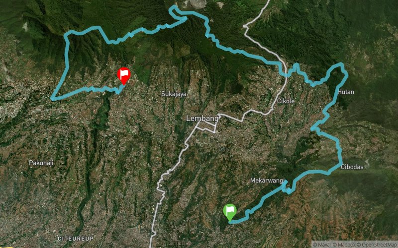
Bandung Ultra 100 is a trail running race offering several categories along the mountain range in the north of Bandung that spans through the municipality and districts of Bandung, West Bandung and Subang. Runners are allowed to finish the course in their own pace within the cut-off time in each race category.


Bandung Ultra 100 - 50K
Distance
0 km
Altitude
981 m
D+
0 m
D-
0 m
10 km
661 m
405 m
WS1 Km 10
Distance
10 km
Altitude
1245 m
D+
661 m
D-
405 m
7.2 km
343 m
190 m
WS2 Km 17
Distance
17.3 km
Altitude
1399 m
D+
1004 m
D-
595 m
8.1 km
327 m
361 m
WS3 Km 25
Distance
25.4 km
Altitude
1369 m
D+
1331 m
D-
956 m
7.5 km
725 m
46 m
WS4 Km 33
Distance
33 km
Altitude
2049 m
D+
2056 m
D-
1002 m
6 km
21 m
518 m
WS5 Km 39
Distance
39 km
Altitude
1548 m
D+
2077 m
D-
1520 m
6.7 km
629 m
899 m
WS6 Km 44
Distance
45.8 km
Altitude
1278 m
D+
2706 m
D-
2419 m
6.6 km
276 m
190 m
Bandung Ultra 100 - 50K
Distance
52.5 km
Altitude
1371 m
D+
2982 m
D-
2609 m
Click on a point of interest to display it on the map
Reviews and times
Add a track
Bandung Ultra 2017

Track number : 43474
Link to track :
https://tracedetrail.fr/en/trace/43474
Log in to insert this track on your website
 Trace de Trail