Show the map
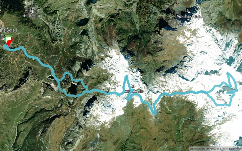
Belle Plagne - Lac de Carrole - Glacier de Bellecôte - Roche de Mio


24 km
1493 m
1497 m

Points of Interest table
Accum. | Intermediary | |||||||
---|---|---|---|---|---|---|---|---|
POI | Description | Alt. | Dist. | D+ | D- | Dist. | D+ | D- |
Trace n°42579
Ascent threshold : 3 m Distance threshold : 30 m Smoothing : Yes Origin of altitudes : MNT Aster GDEM
Loop
Dominant terrain : Footpath
Max alti. : 3079 m
Avg alti. : 2536 m
Min alti. : 2109 m
Longest ascent : 630 m
Longest descent : 610 m
Route completed by the author : nc
Dominant terrain : Footpath
Max alti. : 3079 m
Avg alti. : 2536 m
Min alti. : 2109 m
Longest ascent : 630 m
Longest descent : 610 m
Route completed by the author : nc
Elevation profile

Their last tracks
Col de Chavannes - Col du Petit St-Bernard - Col de la Forclaz - Les Contamines-Montjoie
121.6 km
7950 m
8130 m
Courmayeur (IT)
More tools
Create a new roadbook page
Carte à la Carte IGN
Map and track on your website
Warning ! When you insert a Trace de Trail map on your website, you agree not to hide any element of the module (links to Trail Trail or Trail Connect banner)
Add a realisation
Validate
Add a realisation to share your chrono and describe the conditions that you encountered during you trail running !
Add a comment
Validate
Nearby tracks
1.3 km La Plagne - Crête des Étroits - Mont Jovet - Col du Lac
13.1 km
950 m
950 m
Mâcot-la-Plagne (73)
1.7 km Plagne-Bellecôte - Lac des Blanchets - Roche de Mio - Col de l'Arpette
20.3 km
1180 m
1180 m
Mâcot-la-Plagne (73)
Show the infos
Add a track