
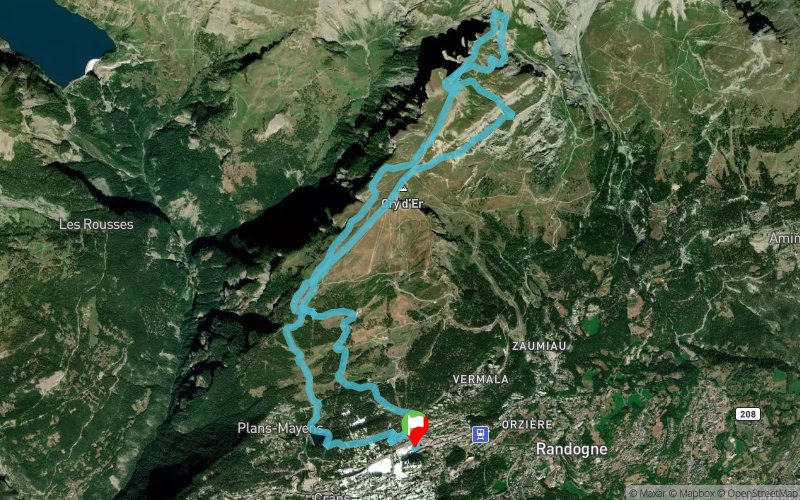
Trail des Patrouilleurs 2022 - 15K
 17.5 km
1250 m
1240 m
17.5 km
1250 m
1240 m
24/09/2022
GPX
181
PDF
Profile
Share
3D
Favorites
Reviews
Like
Randogne (CH) ()
Effort kilometer
Longest ascent
Longest descent
30
1000 m
1050 m
Max. elevation
Min. elevation
Quality index
2555 m
1498 m
 1pt/9m
Track created by traildespatouilleurs
le 2017/06/19 (modified on 2022/06/25)
le 2017/06/19 (modified on 2022/06/25)


Start
Distance
0 km
Altitude
1498 m
D+
0 m
D-
0 m
7.8 km
1042 m
50 m
Distance
7.8 km
Altitude
2499 m
D+
1042 m
D-
50 m
2.8 km
190 m
185 m
Distance
10.7 km
Altitude
2499 m
D+
1232 m
D-
235 m
6.7 km
10 m
997 m
Distance
17.5 km
Altitude
1504 m
D+
1242 m
D-
1232 m
-0.1 km
8 m
8 m
Finish
Distance
17.5 km
Altitude
1498 m
D+
1250 m
D-
1240 m
Click on a point of interest to display it on the map
Reviews and times
Add a track
Trail des Patrouilleurs 2022 - 15K

Track number : 39348
Link to track :
https://tracedetrail.fr/en/trace/39348
Log in to insert this track on your website
 Trace de Trail