
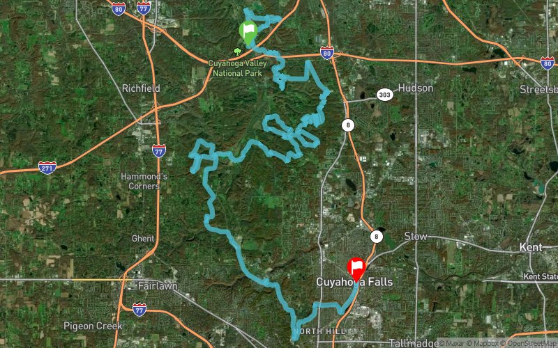
Burning River Endurance Run 2017 - Back 50 Mile
ITRA
 83.9 km
1420 m
1320 m
83.9 km
1420 m
1320 m

GPX
35
PDF
Profile
Share
3D
Favorites
Reviews
Like
Brecksville (US) Cuyahoga Falls (US)
Effort kilometer
Longest ascent
Longest descent
98
100 m
120 m
Max. elevation
Min. elevation
Quality index
336 m
188 m
 1pt/13m
The Burning River Endurance Run & Relay is an exciting 100 and 50 mile solo run and 100 mile relay held in Northeast Ohio. The race travels through several of the region’s most scenic areas, including the Cuyahoga Valley National Park, the Cleveland Metroparks and the Summit Metro Parks.
Track created by westernreserveracing
le 2017/01/02 (modified on 2017/11/14)
le 2017/01/02 (modified on 2017/11/14)

Start
Distance
0 km
Altitude
215 m
D+
0 m
D-
0 m
83.9 km
1413 m
1320 m
Finish
Distance
83.9 km
Altitude
308 m
D+
1413 m
D-
1320 m
Click on a point of interest to display it on the map
Reviews and times
Add a track
Burning River Endurance Run 2017 - Back 50 Mile

Track number : 31341
Link to track :
https://tracedetrail.fr/en/trace/31341
Log in to insert this track on your website
 Trace de Trail