
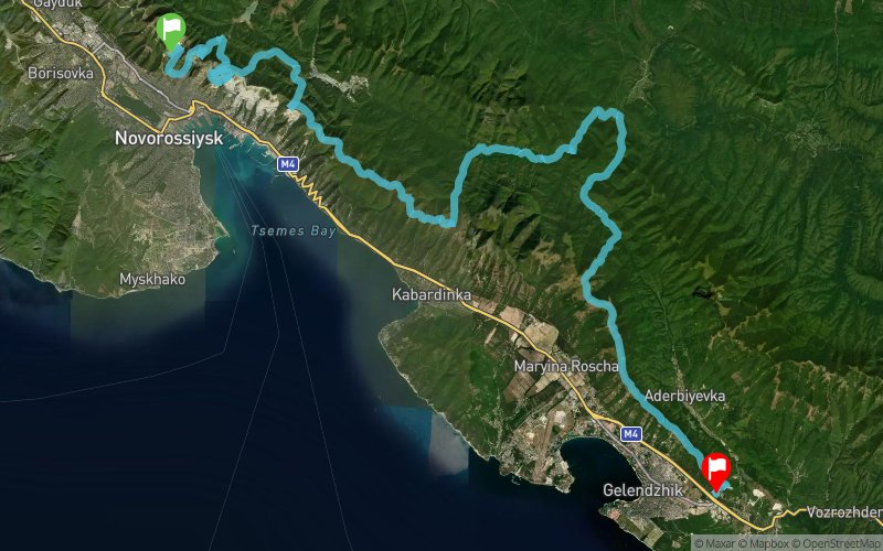
Trail-Ultramarathon Markotkh 2017 - 80 km
ITRA
 79.9 km
3060 m
3160 m
79.9 km
3060 m
3160 m

GPX
247
PDF
Profile
Share
3D
Favorites
Reviews
Like
???????????? 9 (RU) ????????? 8 (RU)
Effort kilometer
Longest ascent
Longest descent
110
580 m
510 m
Max. elevation
Min. elevation
Quality index
759 m
85 m
 1pt/19m
??????? ?? ??? ??? ?? ?????, ??? ???? ???? ????????? ?? ???????? ???? ????????? ???? ???????. ??? ?????????? ?????-????? - ??????????? ???? ? ????? ??, ?? ???? ??????, ??????? ?????????. ????? ????, ??? ???????? ??????? ??? ?? ?????? ? ????????????? ????, ???????? ????? ??????????. ?????-????, ? ??? - ?? ????, ??? ???? ???????? ???, ??? ??????. ???????! ????, ??????????, ?? ????????, ? ??? ??? ???? ? ???… ?????? ?????????? ??????? ?? ?????. ????? ???????? ?? ?????????? ?????? ? ?????????? ??????. ????? ???? ???????, ?? ??????? ???? ??????? ?????? ??????????? ????. ?????????? ?? 15-20. ?? ???? ???? ????? 12 ?????. ??? 13, ? ??????????? ?? ??????. ?? ????????? ?? ???????? - ????????? ?????? ? ??????????? ? ????? ?????????. ???? ?????????? - ?????? ????????? ?????, ? ?? ????. ?? ?????????? ??????, ?? ????????????, ??? ?????????? ?????? ???????? ???????????. ???? ?????? - ?? ????????? ??? ??????? 100??. ?? ????, ??? ITRA ???????? ?? ??? ????? 4 ?????. ???? ????? ??????? - ? ??? ???? ????? ????????? ?????????.
En voir plus... En voir moins...

Start
Distance
0 km
Altitude
244 m
D+
0 m
D-
0 m
79.9 km
3059 m
3154 m
Finish
Distance
79.9 km
Altitude
147 m
D+
3059 m
D-
3154 m
Click on a point of interest to display it on the map
Reviews and times
Add a track
Trail-Ultramarathon Markotkh 2017 - 80 km

Track number : 29867
Link to track :
https://tracedetrail.fr/en/trace/29867
Log in to insert this track on your website
 Trace de Trail