Show the map
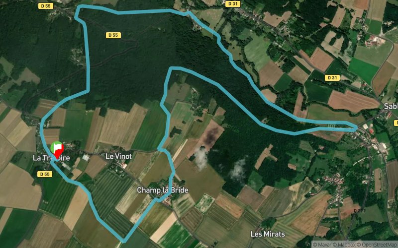
Champ la Bride - La Chenée - La Forge


9.8 km
150 m
150 m

Points of Interest table
Accum. | Intermediary | |||||||
---|---|---|---|---|---|---|---|---|
POI | Description | Alt. | Dist. | D+ | D- | Dist. | D+ | D- |
Trace n°24124
Ascent threshold : 3 m Distance threshold : 0 m Smoothing : No Origin of altitudes : GPS
Loop
Dominant terrain : Path
Max alti. : 179 m
Avg alti. : 118 m
Min alti. : 67 m
Longest ascent : 140 m
Longest descent : 120 m
Route completed by the author : nc
Dominant terrain : Path
Max alti. : 179 m
Avg alti. : 118 m
Min alti. : 67 m
Longest ascent : 140 m
Longest descent : 120 m
Route completed by the author : nc
Elevation profile

Their last tracks
Ultra Trail de la Brie des Morin 2020 - Trail du Tacot Briard
29.6 km
700 m
700 m
Saint-Cyr-sur-Morin (77)
Ultra Trail de la Brie des Morin 2020 - Course des Tétards
12.2 km
240 m
240 m
Saint-Cyr-sur-Morin (77)
Ultra Trail de la Brie des Morin 2020 - Grand Trail du Sonneur
60.5 km
1260 m
1260 m
Saint-Cyr-sur-Morin (77)
More tools
Create a new roadbook page
Carte à la Carte IGN
Map and track on your website
Warning ! When you insert a Trace de Trail map on your website, you agree not to hide any element of the module (links to Trail Trail or Trail Connect banner)
Add a realisation
Validate
Add a realisation to share your chrono and describe the conditions that you encountered during you trail running !
Add a comment
Validate
Nearby tracks
5.7 km Orly-sur-Morin - Sablonnières - Villeneuve-sur-Bellot
28.5 km
930 m
900 m
Orly-sur-Morin (77)
5.8 km Bitibout - Les Neuillis - Archets - L'Hermitière - Bois de l'Église
17.7 km
510 m
510 m
Orly-sur-Morin (77)
5.8 km Les Neuillis - Bois Marcou - Biercy - L'hermitière - Bois de l'Église
25.3 km
660 m
660 m
Orly-sur-Morin (77)
Show the infos
Add a track