
Tracce S1 - Anello San Leonardo
ROUTE TESTED BY THE AUTHOR
 17 km
480 m
480 m
17 km
480 m
480 m

GPX
39
PDF
Profile
Share
3D
Favorites
Reviews
Like
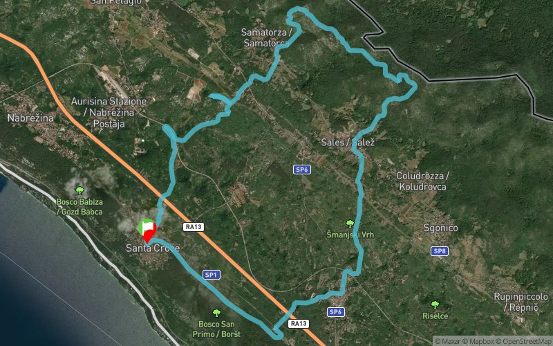
Santa Croce Di Trieste (IT) Santa Croce di Trieste ()
Effort kilometer
Longest ascent
Longest descent
21
280 m
130 m
Max. elevation
Min. elevation
Quality index
394 m
165 m
 1pt/17m
Uscita sociale aperta a tutti.
16 km, 420 D+
Passo: rilassato
Tempo massimo: 3 ore, media 7 min/km
Tempo previsto: 2 ore 15 minuti
Sentieri interessati: CAI 10, CAI 3, Skabar, CAI 43, CAI 41
Difficoltà: Molto Facile!
Voi farla per conto tuo? I sentieri sono di tutti, ecco la traccia!
Una partenza comoda da Santa Croce (foto 138) verso il Monte Scozza(foto 139 e 140) per poi passare dalla Grotta Azzurra al km 4 (foto 141), un attimo di sosta al fresco e via a salire sul Monte San Leonardo al km 7.
Da qui si percorre un tratto molto irrequieto del sentiero Skabar fino al Monte Kosten per poi scendere con una strada agevole fino a Sales, Gabrovizza e giungere di nuovo a Santa Croce.
Ritrovo:
– Mercoledì 1 giugno, ore 18.00 a Santa Croce, Ristoro S1, Benningans PUB
– Per i soci o aspiranti che si prenotano al termine grigliata e bagno in mare opzionale
Note: pantalone lungo o repellente per zecche, almeno 1 L di acqua e lampada frontale.
En voir plus... En voir moins...

Ristoro Santa Croce
Distance
0 km
Altitude
201 m
D+
0 m
D-
0 m
17 km
480 m
480 m
Finish
Distance
17 km
Altitude
201 m
D+
480 m
D-
480 m
Click on a point of interest to display it on the map
Reviews and times
Add a track
Tracce S1 - Anello San Leonardo

Track number : 21582
Link to track :
https://tracedetrail.fr/en/trace/21582
Log in to insert this track on your website
 Trace de Trail