
European Athletics Off-road Championship 2022 – Elite Senior
 8.9 km
1010 m
100 m
8.9 km
1010 m
100 m
01/07/2022
GPX
PDF
Profile
Share
3D
Favorites
Reviews
Like
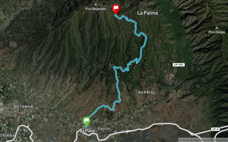
El Paso (ES) Pico Bejenao (ES)
Effort kilometer
Longest ascent
Longest descent
19
540 m
60 m
Max. elevation
Min. elevation
Quality index
1564 m
653 m
 1pt/11m
Un nuevo recorrido creado en exclusiva para la celebración de este primer European Athletics Off-Road Running Championships de la historia. Una vertical ideal para los amantes de las subidas vertiginosas. Un recorrido por las laderas del pico Bejenao sin descansos y en continuo ascenso donde los atletas se van a encontrar corriendo dentro del pinar canario y serpenteando por los antiguos caminos reales del municipio. Aquellos afortunados que puedan levantar la cabeza, disfrutarán de unas vistas privilegiadas que aumentarán de valor paisajístico según se vaya ascendiendo. Una prueba con 8.850 metros de duro trazado en ascenso, una elevación de 997 metros de desnivel y dos avituallamientos (kilómetros 2,5 y meta), que transcurre por senderos perfectamente transitables que permiten poner a prueba las destrezas de cada atleta.
En voir plus... En voir moins...

Start
Distance
0 km
Altitude
655 m
D+
0 m
D-
0 m
8.9 km
1009 m
100 m
Finish
Distance
8.9 km
Altitude
1564 m
D+
1009 m
D-
100 m
Click on a point of interest to display it on the map
Reviews and times
Warning ! This track is only accessible on the day of the competition
Add a track
European Athletics Off-road Championship 2022 – Elite Senior

Track number : 182008
Link to track :
https://tracedetrail.fr/en/trace/182008
Log in to insert this track on your website
 Trace de Trail