
The Pilgrim Challenge 2015 - 66 Miles - 2 Days - Stage 1
ITRA
 54.3 km
1020 m
1040 m
54.3 km
1020 m
1040 m


GPX
7
PDF
Profile
Share
3D
Favorites
Reviews
Like
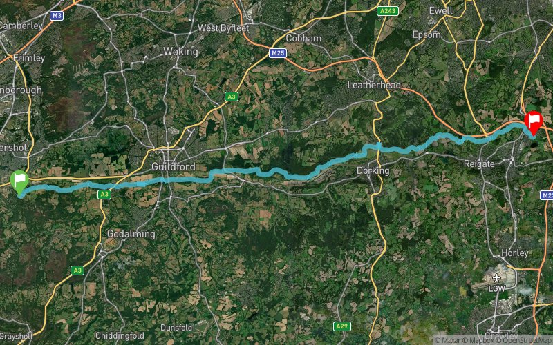
Seale and Sands (GB) Merstham Ward (GB)
Effort kilometer
Longest ascent
Longest descent
64
170 m
190 m
Max. elevation
Min. elevation
Quality index
229 m
18 m
 1pt/8m
The Pilgrim Challenge is a 2 day out and back route along the North Downs Way from Farnham to Merstham with full package including overnight accommodation, food, transportation, a quality medal event technical T shirt and full medical support
Track created by Extreme Energy
le 2016/02/11 (modified on 2016/09/08)
le 2016/02/11 (modified on 2016/09/08)

Start
Distance
0 km
Altitude
85 m
D+
0 m
D-
0 m
54.3 km
1017 m
1031 m
Finish
Distance
54.3 km
Altitude
73 m
D+
1017 m
D-
1031 m
Click on a point of interest to display it on the map
Reviews and times
Add a track
The Pilgrim Challenge 2015 - 66 Miles - 2 Days - Stage 1

Track number : 17946
Link to track :
https://tracedetrail.fr/en/trace/17946
Log in to insert this track on your website
 Trace de Trail