
Abutres Skyrace 2022 - 25km
ITRA
 26.8 km
1590 m
1590 m
26.8 km
1590 m
1590 m


29/05/2022
GPX
36
PDF
Profile
Share
3D
Favorites
Reviews
Like
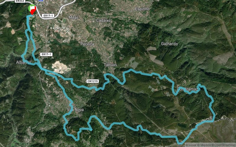
Quinta da Paiva - Miranda do Corvo (PT) Quinta da Paiva - Miranda do Corvo (PT)
Effort kilometer
Longest ascent
Longest descent
42
340 m
490 m
Max. elevation
Min. elevation
Quality index
939 m
102 m
 1pt/11m
Track created by Associação Abutrica
le 2022/04/05 (modified on 2022/04/06)
le 2022/04/05 (modified on 2022/04/06)


Start
Distance
0 km
Altitude
102 m
D+
0 m
D-
0 m
11.8 km
1062 m
228 m
Observatório
Distance
11.8 km
Altitude
938 m
D+
1062 m
D-
228 m
8.2 km
290 m
951 m
Sra Piedade
Distance
20.1 km
Altitude
275 m
D+
1352 m
D-
1179 m
6.6 km
238 m
411 m
Finish
Distance
26.8 km
Altitude
102 m
D+
1590 m
D-
1590 m
Click on a point of interest to display it on the map
Reviews and times
Add a track
Abutres Skyrace 2022 - 25km

Track number : 178233
Link to track :
https://tracedetrail.fr/en/trace/178233
Log in to insert this track on your website
 Trace de Trail