
Sandstone Way North Ultra 2016
ITRA
 115.1 km
1810 m
1720 m
115.1 km
1810 m
1720 m

GPX
19
PDF
Profile
Share
3D
Favorites
Reviews
Like
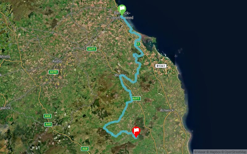
Berwick-upon-Tweed (GB) Rothbury (GB)
Effort kilometer
Longest ascent
Longest descent
133
190 m
170 m
Max. elevation
Min. elevation
Quality index
286 m
2 m
 1pt/10m
The Sandstone Way North Ultra 2016 offers runners an opportunity to run this new 70 mile/114 km Way Marked Trail between Berwick upon Tweed and Rothbury. From the competitors that took part in race last year. They found the North route to include some great runnable sections. After leaving Berwick runners head down the splendid Northumberland coast to nearly Holy Island, before heading inland towards Wooler, Belford and then onto the race finish at Rothbury. This part of Sandstone Way will track the geological ridge, linking sandstone features such as the pink coastal cliffs at Spittal, St Cuthbert’s Cave and Bowden Crag.
En voir plus... En voir moins...

Start
Distance
0 km
Altitude
3 m
D+
0 m
D-
0 m
115.1 km
1802 m
1718 m
Finish
Distance
115.1 km
Altitude
86 m
D+
1802 m
D-
1718 m
Click on a point of interest to display it on the map
Reviews and times
Add a track
Sandstone Way North Ultra 2016

Track number : 17252
Link to track :
https://tracedetrail.fr/en/trace/17252
Log in to insert this track on your website
 Trace de Trail