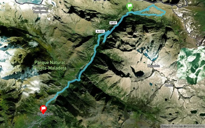
THE GLACIAR TRAIL 26 km in the valley of Benasque while enjoying the views of the glaciers closest to the Equator in Europe. We start at the base of the cross-country ski resort Los Llanos del Hospital then we run around Los Llanos del Hospital, 26 km and 1000 m of elevation gain, where we almost touch the peaks of the mountains that separate the valleys of Benasque, Arán and Bagnères-de-Luchon (France). We turn to the north towards France after running over the massif of Maladeta, for ascension to the “Mirador del Aneto", where we are able to enjoy the impressive view of the Maladeta’s massif and its glaciers we just left behind us.
En voir plus... En voir moins...
Track created by Trail 2 Heaven le 2022/02/04 (modified on 2023/01/01)
Click on a point of interest to display it on the map
Reviews and times
Add a track
Couleur de la trace
Choose a track
Saisir un numéro de trace
Choisir une trace ou une carte
Saisir un numéro de trace
OU saisir un numéro de carte
OU sélectionner une trace ou une carte
Modifier le label
La recherche "Parcours sélectionnés" remonte les parcours possédant l'un des trois labels : Parcours sélectionné, Espace Trail, Univert'trail.
Le label Univert'trail doit être conservé pour que le parcours continue à apparaître dans le widget.
Format gpx
Format GeoJSON
Inclure :
Format csv
Elevation profile
This file contains all the points on the profile with their distance and elevation.
POI table
Trail 2 Heaven 2023 - 26K
Track number :172455
Link to track :
https://tracedetrail.fr/en/trace/172455
Log in to insert this track on your website
Add a review or time
Edit a review or time
OK
Cancel
Trace de Trail
Hello, world! This is a toast message.
Trace de Trail
Hello, world! This is a toast message.
Trace de Trail
Hello, world! This is a toast message.
Welcome to Trace de Trail !
This will enable us to adapt the interface to offer you the most appropriate tools and maps
Newsletter - Trace de Trail !
Our newsletter keeps you up to date with news from Trace de Trail and Trail Connect, as well as Espaces Trail.
New features, online training, contests: make sure you don't miss anything!
We need your consent to continue sending you our newsletter by e-mail (approximately one per month); you can change this choice at any time in your user profile.
Create your Trace de Trail account to take full advantage of the website's features : drawing route, GPX upload, pdf files, personnalised elevation profiles, sharing experiences with the Community...
Your account can also be used on Trail Connect app, the mobile app of Trace de Trail website