
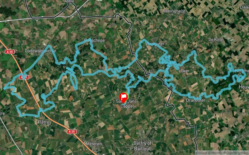
Nord Trail Monts de Flandres 2024 - 80 km
ITRA
 78.6 km
1520 m
1520 m
78.6 km
1520 m
1520 m

17/04/2022
GPX
1259
PDF
Profile
Share
3D
Favorites
Reviews
2 Like
Saint-Jans-Cappel (59) Saint-Jans-Cappel (59)
Effort kilometer
Longest ascent
Longest descent
93
150 m
130 m
Max. elevation
Min. elevation
Quality index
162 m
31 m
 1pt/53m
Track created by philippedes3monts
le 2022/01/11 (modified on 2023/11/26)
le 2022/01/11 (modified on 2023/11/26)

Start
Distance
0 km
Altitude
34 m
D+
0 m
D-
0 m
78.6 km
1513 m
1514 m
Finish
Distance
78.6 km
Altitude
33 m
D+
1513 m
D-
1514 m
Click on a point of interest to display it on the map
Reviews and times
tony2110852023/04/23
2023/04/23 08:28:00
2023/04/23 08:28:00
tony2110852022/04/18
2022/04/17 08:45:00
2022/04/17 08:45:00
Add a track
Nord Trail Monts de Flandres 2024 - 80 km

Track number : 170161
Link to track :
https://tracedetrail.fr/en/trace/170161
Log in to insert this track on your website
 Trace de Trail