Show the map
OFFICIAL ROUTE
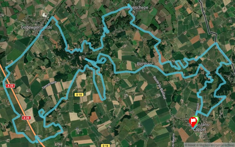
Nord trail monts de Flandres 2022 - 42 km
43.5 km 1150 m 1150 m
départ Saint-Jans-Cappel (59)
arrivée Saint-Jans-Cappel (59)
Points of Interest table
Accum. Intermediary
POI Description Alt. Dist. D+ D- Dist. D+ D-
compet Competition organized on 04/17/2022
Trace n°170136
Ascent threshold : 3 m
Distance threshold : 30 m
Smoothing : Yes
Origin of altitudes : MNT Aster GDEM
Loop
Dominant terrain : Path
Max alti. : 165 m
Avg alti. : 77 m
Min alti. : 22 m
Longest ascent : 140 m
Longest descent : 120 m

Track created by
philippedes3monts
11/01/22
More tools
Create a new roadbook page
To configure the module to be inserted on to your website :
  • choose one layer for your map,
  • choose the dimensions, width and height in pixels, of the module (only iframe)
If you choose OpenCycleMap, Mapbox, Here or Bing Maps, you must sign a contract and get an access key (Menu/My Informations) for display on your website. For swisstopo maps, you have to purchase a Trace de Trail subscription with the swisstopo option.

Warning ! When you insert a Trace de Trail map on your website, you agree not to hide any element of the module (links to Trail Trail or Trail Connect banner)

Add a realisation

Validate
Add a realisation to share your chrono and describe the conditions that you encountered during you trail running !
Add a comment
Validate
avatar
Toone68
28/03/22, 16:40:18
C'est possible de download le gpx du 42km??
Show the infos
Add a track
Add a track
Enter a track number :
OK
Cancel

Log in !

Forgotten password ?
Vous possédez un compte avec une connexion Facebook ou Apple ? Utilisez la fonctionnalité "Mot de passe oublié" pour basculer sur un compte classique.
Create an account

OK
Annuler