Show the map
Certified Track - ITRA
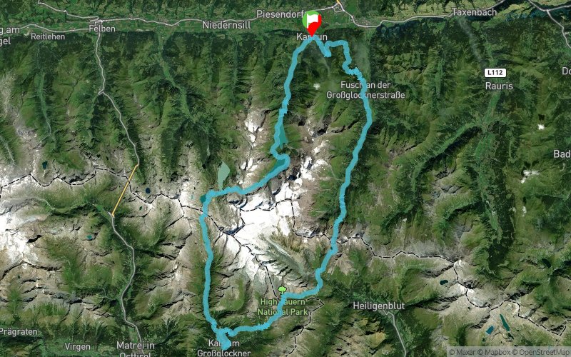
Grossglockner Ultra-Trail 2022 - 109 km
108.5 km 6680 m 6680 m
départ Kaprun (AT)
9
384
Points of Interest table
Accum. Intermediary
POI Description Alt. Dist. D+ D- Dist. D+ D-
compet Competition organized on 07/29/2022
Trace n°164821
Ascent threshold : 3 m
Distance threshold : 30 m
Smoothing : Yes
Origin of altitudes : MNT Google
Loop
Dominant terrain : Footpath
Max alti. : 2675 m
Avg alti. : 1704 m
Min alti. : 769 m
Longest ascent : 1980 m
Longest descent : 2080 m

Elevation profile
Track created by
GGUT
01/11/21
More tools
Create a new roadbook page
To configure the module to be inserted on to your website :
  • choose one layer for your map,
  • choose the dimensions, width and height in pixels, of the module (only iframe)
If you choose OpenCycleMap, Mapbox, Here or Bing Maps, you must sign a contract and get an access key (Menu/My Informations) for display on your website. For swisstopo maps, you have to purchase a Trace de Trail subscription with the swisstopo option.

Warning ! When you insert a Trace de Trail map on your website, you agree not to hide any element of the module (links to Trail Trail or Trail Connect banner)

Add a realisation

Validate
Add a realisation to share your chrono and describe the conditions that you encountered during you trail running !
Add a comment
Validate
Show the infos
Add a track
Add a track
Enter a track number :
OK
Cancel

Log in !

Forgotten password ?
Vous possédez un compte avec une connexion Facebook ou Apple ? Utilisez la fonctionnalité "Mot de passe oublié" pour basculer sur un compte classique.
Create an account

OK
Annuler