
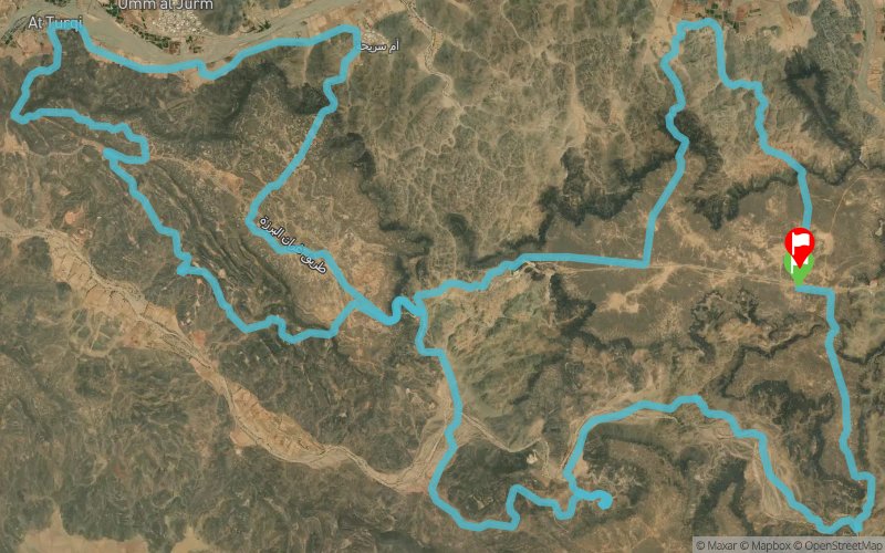
Hejaz50 2020 - 57 km
ITRA
 56.7 km
1320 m
1370 m
56.7 km
1320 m
1370 m

GPX
29
PDF
Profile
Share
3D
Favorites
Reviews
Like
Al Barzah (ND) Al Barzah (ND)
Effort kilometer
Longest ascent
Longest descent
69
460 m
180 m
Max. elevation
Min. elevation
Quality index
323 m
94 m
 1pt/13m
Hejaz50 v6: Trek/Hike, Run, Mountain Bike


Start
Distance
0 km
Altitude
320 m
D+
0 m
D-
0 m
3.1 km
15 m
18 m
CF
Distance
3.1 km
Altitude
317 m
D+
15 m
D-
18 m
5.4 km
74 m
170 m
CP1
Distance
8.6 km
Altitude
221 m
D+
89 m
D-
188 m
2 km
10 m
54 m
WS1
Distance
10.7 km
Altitude
177 m
D+
99 m
D-
242 m
1.1 km
75 m
11 m
CP2
Distance
11.8 km
Altitude
241 m
D+
174 m
D-
253 m
0.7 km
9 m
67 m
CP3
Distance
12.6 km
Altitude
183 m
D+
183 m
D-
320 m
4.7 km
120 m
151 m
CP4
Distance
17.3 km
Altitude
152 m
D+
303 m
D-
471 m
1.7 km
89 m
26 m
WS2
Distance
19.1 km
Altitude
215 m
D+
392 m
D-
497 m
7.4 km
224 m
218 m
X1
Distance
26.5 km
Altitude
221 m
D+
616 m
D-
715 m
4.9 km
63 m
187 m
WS3
Distance
31.5 km
Altitude
97 m
D+
679 m
D-
902 m
4.8 km
65 m
53 m
CP6
Distance
36.3 km
Altitude
109 m
D+
744 m
D-
955 m
3.5 km
214 m
65 m
X2
Distance
39.9 km
Altitude
258 m
D+
958 m
D-
1020 m
1 km
13 m
13 m
X3
Distance
40.9 km
Altitude
258 m
D+
971 m
D-
1033 m
0.9 km
11 m
12 m
X4
Distance
41.9 km
Altitude
257 m
D+
982 m
D-
1045 m
1.6 km
11 m
86 m
WS4
Distance
43.5 km
Altitude
182 m
D+
993 m
D-
1131 m
0.9 km
19 m
28 m
MTB1
Distance
44.5 km
Altitude
173 m
D+
1012 m
D-
1159 m
1.2 km
75 m
3 m
MTB2
Distance
45.8 km
Altitude
245 m
D+
1087 m
D-
1162 m
1.7 km
28 m
6 m
CP7
Distance
47.6 km
Altitude
267 m
D+
1115 m
D-
1168 m
4.5 km
19 m
172 m
CP8
Distance
52.1 km
Altitude
114 m
D+
1134 m
D-
1340 m
4.5 km
186 m
28 m
Finish
Distance
56.7 km
Altitude
272 m
D+
1320 m
D-
1368 m
Click on a point of interest to display it on the map
Reviews and times
Add a track
Hejaz50 2020 - 57 km

Track number : 121858
Link to track :
https://tracedetrail.fr/en/trace/121858
Log in to insert this track on your website
 Trace de Trail