
Ohm Trail Original - 2022
ITRA
 36 km
1860 m
1860 m
36 km
1860 m
1860 m

GPX
118
PDF
Profile
Share
3D
Favorites
Reviews
Like
Aywaille (BE) Aywaille (BE)
Effort kilometer
Longest ascent
Longest descent
54
220 m
190 m
Max. elevation
Min. elevation
Quality index
393 m
120 m
 1pt/13m
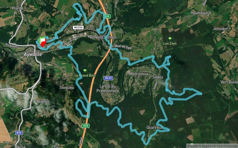
L’Ohm, l’unité de mesure de la résistance a l’effort symbolise parfaitement ce trail dont le parcours proposé regorge de difficultés comme, pour ne citer que cet exemple, un dénivelé de 1850m D+ sur le parcours de 35km, ce qui est un record en Belgique. Vous alternerez passages techniques, single tracks, passages roulants, montées et descentes.
Cependant, ce qui fait surtout l’attrait de cette épreuve est son parcours. Un parcours magnifique qui emmène les trailers à travers des réserves naturelles, des sentiers comparables à ceux que l’on trouve dans les montagnes en France et leur fait ainsi découvrir les splendides coins sauvages de la région d’Aywaille comme La terriblement belle vallée du Ninglinspo, variée dans tous les sens du terme, ludique et corsée… Un régal tout comme les autres lieux traversés: la Haie des Gattes, les Fonds de Quarreux et d’autres lieux enchanteurs.
Veritable trail aussi dur que magnifique, L’Ohm trail vous fera souffrir ave le sourire !
En voir plus... En voir moins...


Start
Distance
0 km
Altitude
120 m
D+
0 m
D-
0 m
2 km
80 m
3 m
Point photo 1
Distance
2 km
Altitude
197 m
D+
80 m
D-
3 m
9.9 km
446 m
471 m
Point photo 2 (pont en bois)
Distance
11.9 km
Altitude
172 m
D+
526 m
D-
474 m
1 km
129 m
3 m
Point photo 3 (grosse cote)
Distance
13 km
Altitude
298 m
D+
655 m
D-
477 m
6.1 km
367 m
396 m
Point photo 4 (Ninglinspo)
Distance
19.1 km
Altitude
269 m
D+
1022 m
D-
873 m
1.8 km
30 m
113 m
Ravito 2 (Ninglinspo)
Distance
21 km
Altitude
184 m
D+
1052 m
D-
986 m
4.6 km
258 m
281 m
Point photo 5 (passage sous autoroute)
Distance
25.6 km
Altitude
163 m
D+
1310 m
D-
1267 m
1.1 km
47 m
40 m
Ravito 3 (Secheval)
Distance
26.7 km
Altitude
170 m
D+
1357 m
D-
1307 m
8.7 km
501 m
491 m
Point photo 6 (Derniere Cote)
Distance
35.5 km
Altitude
180 m
D+
1858 m
D-
1798 m
0.1 km
0 m
20 m
Point photo 7 (Pied Heid des gattes)
Distance
35.6 km
Altitude
160 m
D+
1858 m
D-
1818 m
0.3 km
2 m
42 m
Finish
Distance
36 km
Altitude
120 m
D+
1860 m
D-
1860 m
Click on a point of interest to display it on the map
Reviews and times
Add a track
Ohm Trail Original - 2022

Track number : 102381
Link to track :
https://tracedetrail.fr/en/trace/102381
Log in to insert this track on your website
 Trace de Trail