
Belasitsa Sky Run 2018 - Short
ITRA
 32.9 km
1950 m
2040 m
32.9 km
1950 m
2040 m

Like
Favorites
Reviews
Share
GPX
3
PDF A4
PDF A0
Profile
Flyover
3D
Insert
Passages
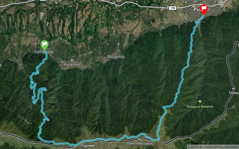
????????? / Samuilovo (BG) ?????? / Petrich (BG)
Effort kilometer
Longest ascent
Longest descent
52
1810 m
1720 m
Max. elevation
Min. elevation
Quality index
2008 m
222 m
 1pt/15m
Belasitsa Sky Run is a trail running race that follows the ridge of one of the mountains with the most beautiful panoramas on the Balkan Peninsula.
During the event the participants will enjoy views of three countries (Bulgaria, FYR Macedonia and Greece) and will see the three highest mountains on the Balkans (Rila, Olympus and Pirin). Two beautiful lakes (Dojran and Kerkini) make the panoramas even more breathtaking, while Struma River valley and the picturesque villages at the foot of the Mountain add to the atmosphere of the race part of which runs in midst of the centuries-old chestnut forests - the symbol of Belasitsa Mountain.
Belasitsa Sky Run Short route is 32,8 km long and starts from the village of Samuilovo going through old growth plane tree forest, by the Shy (Kamenishki) waterfall and Lopovo locality before climbing to the highest peak of Belasitsa - Radomir (2029 m.a.s.l.) continues along the picturesque ridge to Kongur Peak and descends through centuries-old beech and chestnut forests to the finish in Petrich.
En voir plus... En voir moins...

Start
Distance
0 km
Altitude
318 m
D+
0 m
D-
0 m
32.9 km
1942 m
2038 m
Finish
Distance
32.9 km
Altitude
222 m
D+
1942 m
D-
2038 m
Click on a point of interest to display it on the map
Reviews and times
Add a track
Belasitsa Sky Run 2018 - Short

Track number : 63734
Link to track :
https://tracedetrail.fr/en/trace/63734
Log in to insert this track on your website
 Trace de Trail